Arizona State Route 187

|
|
|---|---|
| map | |

|
|
| Basic data | |
| Overall length: | 5.43 mi / 8.74 km |
| Opening: | 1944 |
| Starting point: | at AZ 387 |
| End point: | at AZ 87 |
| County: | Pinal County |
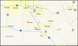
The Arizona State Route 187 (short- AZ 187 ) is a state highway in the US state of Arizona , which runs north-south direction.
The State Route begins on Arizona State Route 387 north of Casa Grande and ends after 8.7 kilometers near Sacaton on Arizona State Route 87 . It runs through the Gila River Indian Reservation and is often used as a shortcut for traffic to Phoenix when Interstate 10 is closed in that direction.
Until 1984, today's AZ 387 route between I-10 and Casa Grande was still part of AZ 187.
See also
Web links
- Arizona Roads: AZ 187 (English)
Individual evidence
- ↑ Arizona Highway Data: ADOT Right-of-Way Resolutions 1944-P-009, 1984-12-A-085 , accessed February 8, 2011