Arrawarra
| Arrawarra | |||||
|---|---|---|---|---|---|
 Pedestrian bridge over Arrawarra Creek overlooking Arrawarra Beach (2016) |
|||||
|
|||||
|
|||||
|
|||||
|
|||||
|
|
|||||
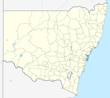
Arrawarra is a suburb of Coffs Harbor in New South Wales , Australia . It is part of the Local Administrative Area (LGA) of Coffs Harbor City . During the 2011 census, 516 people lived there.
geography
The beach area of Arrawarra borders in the north and west on Corondi Beach and in the south up to the Arrawarra Headland . The 2.2 kilometer long beach on the Australian east coast does not have a name of its own, but is part of Condi Beach.
Arrawarra Creek
The Arrawarra Creek , an estuary , has an approximately 200-wide estuary into the Pacific between Arrawarra and Arrawarra Headland . The estuary is in good ecological condition and has great cultural significance for the local Aborigines.
Web links
Individual evidence
- ↑ a b Australian Bureau of Statistics : Arrawarra (State Suburb) ( English ) In: 2016 Census QuickStats . June 27, 2017. Retrieved January 26, 2020.
