Asshole
The Arschlochwinkel , also written as Arschlochwinkl , is a hiking and climbing area at the foot of the Dachstein massif in the Salzkammergut in Austria.
Location and naming
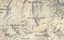
The corner of the asshole is located south of Lake Hallstatt , on the northern slope of the Dachstein, in the south of the Hallstatt Zwölferkogel ( 1979 m ), at an altitude of about 1800 m . The Brenntgenkogl ( 1932 m ) is 300 m south of the Arschlochwinkel .
According to legend, the name was asshole angle towards the end of the 19th century, when the first surveyors of k. u. k. Monarchy mapped the Dachstein area . In the topographical land survey , it was an important task, if possible, the names of all parts of the landscape (in addition to surveying the terrain field names ) and settlement objects detected with to and in the topographic maps entered. However, many of these points were nameless even with the locals. Annoyed by the constant questioning of strangers, the locals are said to have made fun of inventing names that were then taken over directly by the surveyors.
The name Arschlochwinkel can now be found almost exclusively on older maps of the Dachstein Mountains and some hiking maps.
literature
- Apparently the asshole angle actually exists. In: mainpost.de . August 3, 2006, accessed December 29, 2015 .
- lene / kri: Greetings from the asshole angle . In: mainpost.de. December 29, 2015, accessed December 29, 2015 .
Web links
- Map section with the corner of the asshole , on raveheart.org/lol
- Day 2: We land in the corner of the asshole. 2-day tour Krippenstein (on weissenboek.com)
Individual evidence
- ↑ Werner Stanzl: Many greetings from Kotzgraben. In: wienerzeitung.at . July 17, 2012, accessed December 29, 2015 .
- ^ Alpenverein Freistadt: Der Wackelstein, Annual Program 2014/2015 OeAV Section Freistadt, Issue No. 21, November 2014
- ↑ What's new? Broadcast from 10/27/06. In: tv.orf.at. October 27, 2006, accessed December 29, 2015 .
- ↑ Harald Havas: Tourists love places from Poppendorf to Votzenthal. In: welt.de . July 16, 2015, accessed December 29, 2015 . after: Harald Havas : Curious Austria. Metroverlag.
- ↑ MountMcKinley: The Seewand via ferrata. In: sueddeutsche.de . September 11, 2010, accessed December 29, 2015 .
Coordinates: 47 ° 31 '44.4 " N , 13 ° 38' 48" E
