Assekrem
| Assekrem | ||
|---|---|---|
|
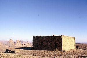
Assekrem - Charles Foucaulds Hermitage built in 1911 |
||
| height | 2780 m | |
| location | Algeria , North Africa | |
| Mountains | Atakor , Ahaggar Mountains | |
| Coordinates | 23 ° 15 '49 " N , 5 ° 37' 52" E | |
|
|
||
| Type | High plateau | |
The Assekrem is one of the highest mountain plateaus in Algeria . Its height is indicated there on a plaque as 2,780 m. 2804 m is also mentioned variously as the summit height. Other sources come to significantly lower values between 2,700 m and 2,720 m.
location
The mountain plateau extends over more than 80 hectares. The Tahat , the highest mountain in Algeria, rises about 12 km (as the crow flies) to the west. From the small town of Tamanrasset , located approx. 50 km (as the crow flies) further south, an approx. 82 km long slope leads to the plateau.
tourism
The summit region of Assekrem is a popular place because Charles de Foucauld built a hermitage there in 1911 . In a letter he wrote: “The beauty of the view surpasses all words and ideas. Nothing can describe the magic of this forest of pinnacles and needles that you have at your feet. What a miracle!"
The plaque of the Touring-Club de France, dated 1939, with the sketched and inscribed mountain panorama is embedded in the forecourt, which is presented to the viewer from the north-east to south to south-west from here. If the height of 2,780 meters given on the sticker refers to the location of the badge, which is not identical to the summit, this traditional height is increased by a good 100 meters to the same extent as for the nearby Tahat, because for the According to current measurements, the location of the badge varies between 2,660 and 2,680 meters.
See also
Web links
- 1911 Assekrem in the Hoggar Mountains
- Hoggar, Atakor et Assekrem (Algérie). November 2008
- Assekrem at Geonames
Individual evidence
- ^ Marking of the Touring-Club de France in front of the Hermitage
- ↑ top contour line according to OpenTopoMap
- ↑ Transfer of the article coordinates to GeoLocator shows elevation: 2720 m - while choosing the OCM map display the height 2710 m is not reached
- ↑ Assekrem - map with altitude information


