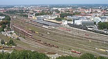
Augsburg-Bahnhofsviertel
The Bahnhofsviertel is a district of Augsburg that belongs to the inner city planning area . Together with the Bismarckviertel and the Beethovenviertel , it forms the 3rd district of the Bahnhofs- and Bismarckviertel .
history
With its emergence from 1845, the Augsburg train station district is one of the younger parts of the Fuggerstadt.
When the main station (today the oldest still in operation in a major German city) was opened in front of the medieval city walls of Augsburg , it was initially located in the middle of undeveloped wasteland and could only be reached with a lot of effort via the Gögginger Tor . The protest of the citizens was not long in coming.
In 1862 - the Augsburg main station had developed into one of the most important train stations in Bavaria - the city government ordered the demolition of the Gögginger Tor and the city wall from today's Theodor-Heuss-Platz to the city theater . The main station was no longer cut off from the city center by the old fortifications and a modern part of the city could emerge on the open spaces.
In accordance with the Wilhelminian style of representation at the end of the 19th century, the development of the future station district was intended to give a worthy expression of the increasing importance of the Fuggerstadt. A 48-meter-wide avenue was created between the newly laid out Kaiserplatz (today Theodor-Heuss Platz) in the south and the city theater in the north, which was lined with noble Wilhelminian style villas and large department stores. At the former location of the Gögginger Tor, the Königsplatz with its park and tram stops formed the center of the boulevard . The station district itself was mainly built with residential and commercial buildings in the historicizing style typical of the time.
Whereas before the Second World War it was mainly Bahnhofstrasse that played the role of the “lifeline” in the Bahnhofsviertel, Halderstrasse has been the second main axis from Königsplatz to the main train station since the 1970s at the latest. It leads south of the train station to Königsplatz. Its south-facing development mainly dates from the 1980s and 1990s, when large open spaces were created with the demolition of a large freight hall of the former Federal Railway. Mainly insurance companies, banks and hotels have settled here. The most important culturally and historically significant building on Halderstrasse is the Augsburg Synagogue , an Art Nouveau building from 1914.
Current developments
After the use of the loading yards southeast of the main station was given up at the end of the 1990s, these areas developed into unused fallow land. In 2012, the site began to be prepared for the construction of the so-called Beethoven Park, a residential area with 230 residential units. For this purpose, clearing and demolition work was carried out first.
Individual evidence
- ^ Frank Möller: Bourgeois rule in Augsburg 1790-1880 . Oldenbourg Wissenschaftsverlag, 1998, ISBN 3-486-56387-4 , p. 386 .
- ^ Franz Häußler: The hotel mile at the train station is a thing of the past. In: augsburger-allgemeine.de , October 24, 2007, accessed on October 25, 2017
- ↑ Demolition of the first loading yards. In: Augsburger Allgemeine , March 2, 2012
Web links
Coordinates: 48 ° 22 ' N , 10 ° 53' E


