Austin Dam

Coordinates: 41 ° 39 '10.4 " N , 78 ° 5' 7.3" W.
The Austin Dam (Austin Dam, also: Bayless Dam) was a dam near the city of Austin , Potter County, in the US state of Pennsylvania , which was completed in 1909. It broke on September 30, 1911 and led to the second largest flood disaster in Pennsylvania after the South Fork disaster .
The construction of the dam
The gravity dam made of concrete was built in 1909 at Freeman's Run in Austin to supply water to the paper mill of George Bayless. This commissioned the civil engineer T. Chalkey Hatton from Wilmington, Delaware with the construction. At that time, concrete (with reinforcing steel) was still an unusual building material for dams . The wall was built 1.2 m (4 feet) deep in sandstone.
Construction began on May 8, 1909 and ended on December 9, 1909. It was built very quickly and economically; Various design proposals by the engineer were rejected by the client for reasons of cost. The construction cost was 86,000 or $ 88,000.
The dam was 15 m (50 feet) high and 165 or 167 m (534 or 550 feet) long and was the largest dam in Pennsylvania. According to various sources, the stowage volume was 678,000 or 1.05 million m³ (or 250 or 265 million US gallons ). - The reservoir was 12 m (40 feet) deep.
The catastrophe
The dam soon cracked. In January 1910 there was a thaw, the dam was filled and overflowed. The wall is said to have bent by 11 m (36 ft) at the top under the load (however, this information is incredibly large and certainly incorrect). A 4 m (13 ft) piece broke away on the western slope. The wall at the foot of the wall had also evaded. Still, it was now believed to be safe.
In the following year, in normal weather, it suddenly broke due to structural failure in the foundation joint or in the subsoil. The time is given as 2:05 p.m., 2:20 p.m. or 2:29 p.m. A witness (Cora Brooks, who is said to have been a prostitute), observed the break from her house and called by phone in the city of Austin, which was 2,400 m below and had 2,000 inhabitants at the time. Two switchboard operators (Lena Binckley and Kathleen Lyons) warned residents of the city by shouting loudly, which saved many. The tidal wave hit the paper mill first. An alarm signal was also triggered there (eight short and one long beeps).
According to official information, at least 78 people were killed by the tidal wave . All of the fatalities were in the two miles (3200 m) directly below the dam. The damage totaled US $ 14 million. The tidal wave was made worse by the fact that it carried a lot of logs. Many victims got caught in a cattle fence below the city and died as a result.
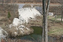
The ruins of the dam can now be reached and visited north of Austin west of Route 872 via a gravel road. In 1989 the site was added to the National Register of Historical Places and is owned by the Austin Dam Memorial Association.
literature
- Donald C. Jackson: Great American Bridges and Dams. John Wiley & Sons, New York 1984, ISBN 0-471-14385-5 , pp. 330-331.
- Marie Kathern Nuschke: The Dam That Could Not Break. An Eye Witness Account of the 1911 Austin Flood. Plank's Suburban Press, Camp Hill 1960, OCLC 14139629 .
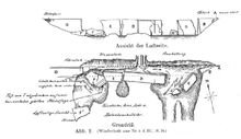
- The destruction of the Austin Dam in Pennsylvania, North America. Zentralblatt der Bauverwaltung, D. Link, 1912.
See also
Web links
- Street and waterway map of Potter County on bridgehunter.com
- THE AUSTIN FLOOD REMEMBERED on coudy.com
- Austin Dam. In: Structurae
- Austin dam memorial association on austindam.net


