
Bab al-Futuh


The Bab al-Futuh ( Arabic باب الفتوح, DMG Bāb al-Futūḥ 'Gate of Conquests') is one of the three still-preserved city gates of the medieval city of al-Qahira, the palace city of the Fatimid dynasty founded in 969 AD giving its name to today's Cairo , the capital of Egypt . has become. Just like the Bab an-Nasr , the Bab al-Futuh leads north out of the city, while the Bab Zuweila forms a path south.
City foundation: first wall and first gates
After the conquest of Egypt by the Fatimid general Dschauhar as-Siqillī in 969, his master, the Fatimid caliph al-Muizz li-Din Allah , who had previously resided in Kairuan (Tunisia) , decided to move his residence to Egypt. The victorious general was commissioned to build a new palace city for his master near the previous Egyptian capital al-Fustat . To the north-east of al-Fustat, Dschauhar had the city of al-Qahira built with palaces, gardens and residential quarters for the dignitaries and soldiers of the occupying forces from 970, which he enclosed with a wall of adobe bricks. Several gates led through this wall in all directions.
In the center of the new palace and garrison city al-Qahira was a large square that had been created “between the two palaces” (Arabic: “Baina al-Qasrain”). The main street of al-Qahira ran through the square, from Bab al-Futuh in the north to Bab Zuweila in the south. This street was used by the caliphs for splendid parades and processions.
This main traffic axis at that time is now known as al-Muizz Street and is a major tourist attraction in Cairo due to the many Islamic monuments located here.
New city wall of Badr al-Jamali
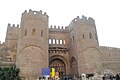
Outside of Bab al-Futuh, seen from the north

Inside of the gate, seen from the south

Decoration of the passage up close

Wall inscription next to the Bab al-Futuh


In the 11th century, the Fatimid Empire ran into serious trouble. National bankruptcy and various uprisings brought the empire to the brink of dissolution. In this situation, the governor of Damascus Badr al-Jamali received extensive special powers from the caliph al-Mustansir and thus a de facto regency. He defeated the Seljuks , reorganized the state administration and finance and promoted economy and trade. One of his achievements was a completely new stone wall around al-Qahira in 1087, which replaced the old adobe wall and was supposed to repel further attacks by the Seljuks. The new wall essentially ran just outside the previous city limits with a few extensions. It now encompassed the al-Hakim mosque in the north , which had previously stood outside the wall. Immediately to the west of the mosque was the Bab al-Futuh, which is still visible today. Further east, also in the north wall, the Bab an-Nasr . In the south, the new wall ran a significant distance further south, expanding the city by a wide strip. The new Bab Zuweila was built here around 1091/1092 and is still standing today.
According to architectural historians, these three gates show features of the Byzantine style . The Cairene historian al-Maqrīzī reports that Badr al-Jamali commissioned three Christian monks from Edessa in eastern Anatolia who had fled the Seljuks to al-Qahira to build the three gates .
The Bab al-Futuh is now a major attraction in modern Cairo.
literature
- Oleg V. Volkoff: 1000 years of Cairo. History of an enchanting city. Mainz 1984, ISBN 3-8053-0535-4 .
- Doris Behrens-Abouseif: Islamic Architecture in Cairo. An Introduction. 1st edition Cairo 1989, 5th edition Cairo 2005, ISBN 977 424 203 3 , p. 69.
- Heinz Halm : The Caliphs of Cairo. The Fatimids in Egypt (973-1074) . Beck, Munich 2003, ISBN 3-406-48654-1 .
Web links
Individual evidence
- ↑ alrahalah.com: AL-MU'IZZ STREET - CAIRO'S GRAND STREET
- ^ Oleg V. Volkoff: 1000 Years of Cairo. History of an enchanting city. Mainz 1984, ISBN 3-8053-0535-4 , p. 95.
- ^ Doris Behrens-Abouseif: Islamic Architecture in Cairo. An Introduction. 1st edition Cairo 1989, 5th edition Cairo 2005, ISBN 977 424 203 3 , p. 72
Coordinates: 30 ° 3 ′ 19.9 ″ N , 31 ° 15 ′ 48.3 ″ E