Badger Island (Tasmania)
| Badger Island | ||
|---|---|---|
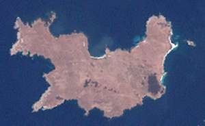
| Satellite image of the island | ||
| Waters | Bass Street | |
| Archipelago | Chappell Islands | |
| Geographical location | 40 ° 18 ′ S , 147 ° 55 ′ E | |
|
|
||
| length | 6.2 | |
| width | 2.8 | |
| surface | 1244 ha | |
| Residents | uninhabited | |
| Relief map of the Chappell Islands | ||
Badger Iceland is the largest island of Chappell Islands within the Furneaux archipelago , which the Australian state of Tasmania is one. It is located in the center of the Chappell Islands between the main island of Tasmania and Victoria in the Bass Strait , west of Flinders and Cape Barren Island .
Aborigines used the island for at least 20,500 years, among other things, from breeding birds there ( mutton birds ) to feed. With the discovery of the Bass Strait by George Bass and Matthew Flinders in 1798, Europeans came to the area to exploit the natural resources. First came seal hunters who, after the seal colonies were exhausted in 1838, switched to the Mutton Bird shop. Families living on nearby islands continued to operate this until the 1950s; the last season was 1975. Sheep have also been kept on the island since the 1860s.
As a result of these uses, the originally forested island was affected: Sheep trampled bird's nests, the native vegetation suffered, instead foreign plants and animals were brought in. In 1995 the island was given to the Aboriginal community; since 2000 it has been an Aboriginal protected area (Indigenous Protected Area) .


