Balabalagan Islands
| Balabalagan Islands | ||
|---|---|---|
| Waters | Strait of Makassar | |
| Geographical location | 2 ° 20 ′ S , 117 ° 25 ′ E | |
|
|
||
| Number of islands | Anak Malamber , Labia , Malamber , Popoongan , Sabakkatang , Saboyang , Salingsingan , Salingsingang , Samataha , Seloang , Tappilagang | |
| Main island | Ambo | |
| Total land area | 21.86 km² | |
| Residents | 2611 (2015) | |
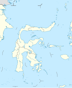
The Indonesian Balabalagan Islands or Small Paternoster Islands ( Indonesian Kepulauan Bala-Balakang, Balabalakang, Gugus Pulau Ambo ) are located in the Makassar Strait between Borneo (Kalimantan) and Sulawesi (Celebes). They belong to the West Sulawesi Province (Sulawesi Barat).
geography
The small islands form a district (Kecamatan) of the administrative district of Mamuju (Kabupaten Mamuju) . The district was separated from Simboro in 2010 . The district of Kepulauan Bala-Balakang is divided into the three administrative villages of Kepulauan Bala-Balakang (the main town), Bala-balakang Timur and Popoongan .
The islands are made up of corals and coral sand. A source from the 19th century reports islands that are densely forested. It also says here that the channels between the islets are difficult to navigate, but are rich in fish, which the local Bajau used.
The main island is Ambo (Pulau Ambo) , about 202 kilometers from Mamuju on Sulawesi. Other islands are Anak Malamber , Labia , Malamber , Popoongan (Popo'ongan, Popoongang), Sabakkatang , Saboyang (Saboeang), Salingsingan , Salissingang , Samataha , Seloang and Tappilagang . The islands are also known as archipelagos because they are not compact. Ambo is divided into north and south ambo.
There is a fresh water source only on Saboyang, otherwise the residents are dependent on rainwater for supply.
Residents
In 2015 there were 2,611 people on the islands, some of which are uninhabited. The inhabitants are mainly Mandar , there are also minorities of Macassars , Northern Moluccas and Bajau. The residents of Salingsingang come from the Majene administrative district and did not immigrate until the beginning of the 20th century, while Ambo has long been used as a base by Mandar fishermen.
Economy and Transport
One lives from fishing, although there are always conflicts because of illicit dynamite fishing . Tappilagang, which lies apart from the other islands in the north, is often used as a base by the dynamite fishermen. The islands are called by boats from Mamuju and Balikpapan (on Borneo). In particular, Salissingang and Sabakkatang, which are closer to Borneo than Sulawesi, receive everyday items from Balikpapan.
Oil deposits are known.
Since 2014, Ambo has had a solar power system for around 100 families in the villages of North and South Ambo.
Individual evidence
- ↑ a b c Statistical data from Mamuju from 2016 (Indonesian)
- ↑ Mandar Kareba: Pulau Ambo, Surga Wisata Yang Tersembunyi Di Mamuju , accessed on November 9, 2017.
- ↑ a b c d Ekspedisi Sulbar: Gugus Pulau Ambo di Selat Makassar, Antara Mamuju & Balikpapan , accessed on November 9, 2017.
- ^ Michael Leifer: Malacca, Singapore, and Indonesia , p. 81, 1978, ISBN 9789028607781 .
- ^ George Newenham Wright: A New and Comprehensive Gazetteer, Volume 1 , 1834.
- ↑ a b Kommunitas Penggiat Budaya & Wisata Mandar: Pulau Ambo, Potensi Wisata Bahari Kota Mamuju Sulawesi Barat , March 1, 2014 , accessed on November 9, 2017.
- ↑ Antara News: Warga Pulau Ambo Nikmati Listrik Tenaga Surya , January 10, 2014 , accessed on November 9, 2017.
