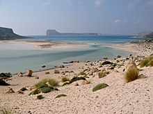
Balos
Balos ( Greek Μπάλος ) is a bay with a lagoon behind it on the west coast of the Greek Mediterranean island of Crete . It is located in the Kissamos municipality of the Chania regional district .
Geographical location
The bay of Balos is located on the west side of the now uninhabited peninsula Gramvousa (Γραμβούσα). The peninsula, four kilometers wide in the south, extends from the last settlement Kaliviani 12 kilometers north to Cape Vouxa (Ακρωτήρι Βούξα), the northwesternmost point of the island of Crete. At the height of Balos , five kilometers southwest of Cape Vouxa , Gramvousa is only about one kilometer wide.
The lagoon to the east of the Bay of Balos (Όρμος Μπάλος) between the Gramvousa peninsula and the adjoining Cape Tigani to the west (Ακρωτήρι Τηγάνι, translated: "pan") has a northern connection to the open sea at the Bay of Gramvousa (Όραμς Γοαμousa) to which the lagoon actually belongs. The approximately one kilometer long and 700 meter wide peninsula of Cape Tigani , which rises to a height of 117 meters, is only connected to the mainland near Balos by a flat, approximately 50 meter wide land bridge . The lagoon extends east of this land bridge with an east-west extension of about 400 meters, about 600 meters from the open sea to the south.
description
The bay of Balos with the lagoon of Gramvousa is one of the main natural attractions of Western Crete , along with the island of Elafonisi and the Samaria Gorge . The bays were created by the gradual tectonic uplift of the island in the west and the resulting land connection between Crete and the formerly offshore island of today's Cape Tigani . In the protection of this land bridge to the open sea, the lagoon could form to the east of it due to alluvium.
The lagoon beach consists of fine white shell and coral sand. The water that is shallow in large parts of the lagoon and below 50 centimeters does not show any vegetation. The coastal areas characterized by dunes are also only sparsely covered with vegetation. On the shores of the bay there are many small lumps of tar in the sand that are washed up by westerly winds and are said to have come from tankers who illegally clean their tanks on the open sea.
The flat land connection to Cape Tigani consists of natural cement (layers of cemented sand) in which water holes have formed. On the southern edge of the lagoon is a tavern that is open in summer and closes in October. For a number of years there has been a canteen in the town of Kissamos in the direction of the Tigani peninsula , offering small dishes. In addition, loungers and parasols can be rented from there. The cantina is usually open until the end of October. Otherwise the area is undeveloped and there is no further infrastructure. Only on the peninsula of Cape Tigani is there a small chapel and on the offshore island of Imeri Gramvousa (Ήμερη Γραμβούσα) there are the ruins of a Venetian fort from the 16th century.
Access
Shortly after the village of Kaliviani, the asphalt road ends and an unpaved road runs northwards for about eight kilometers on the east side of the Gramvousa peninsula . Halfway there is the small chapel of Agia Irini above the coast of the Gulf of Kissamos (Κόλπος Κισσάμου). At the end of the dirt road there is a tavern with a parking lot about 100 meters above sea level. To the bays of Balos and Gramvousa , about one kilometer away as the crow flies , a footpath leads to the west, followed by a stone staircase built in 1999.
Another possibility to reach the bays is offered by the excursion boats that operate daily from Kissamos during the tourist season (end of April to end of October), which also call at the offshore island of Imeri Gramvousa . These ship connections have made the lagoon an important economic factor for the residents of the Kissamos community in recent years.
Individual evidence
- ^ Eberhard Fohrer: "Kreta", Michael-Müller-Verlag, 16th edition 2006
- ↑ D. Kelletat (1979): Geomorphological studies on the coasts of Crete - contributions to the regional coastal morphology of the Mediterranean area. - Dep. Akad. Wiss. Göttingen Math.-Phys. Kl., 3. F. 32. - Vandenhoeck & Ruprecht, Göttingen. 105 pp.
- ↑ Crete impressions / West Crete / Gramvoúsa
- ↑ Gramvousa & Balos - with daily boat connections to the Balos lagoon
Web links
Coordinates: 35 ° 34 ′ 58 ″ N , 23 ° 35 ′ 20 ″ E


