
Banni (Upper River Region)
| Banni | ||
|---|---|---|
|
Coordinates: 13 ° 23 ′ N , 14 ° 15 ′ W |
||
| Region: | Upper River | |
| District: | Wuli | |
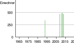
| Residents: | 457 (2013)
|
|
|
||

Banni (name variants: Bajonkoto or Batankoto ) is a town in the West African state of Gambia .
According to a calculation for 2013 there about 457 inhabitants, the result of the last published live census of 1993 was the 330th
geography
Banni lies on the north bank of the Gambia River , in the Upper River Region District Wuli . The place is about three kilometers west of Sutukonding .
See also
Individual evidence
- ↑ Banni on bevoelkerungsstatistik.de (no longer available online, last accessed May 2013)