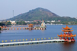
Banpingshan
| Banpingshan | ||
|---|---|---|
|
View of the mountain across Lotus Lake |
||
| height | 220 m | |
| location | Taiwan | |
| Coordinates | 22 ° 41 '57 " N , 120 ° 18' 41" E | |
|
|
||
The Banpingshan ( Chinese 半 屏山 , Pinyin Bànpíng Shān , Pe̍h-ōe-jī Poàⁿ-pêng-soaⁿ ) is a mountain in the southern Taiwanese city of Kaohsiung .
geography
Banpingshan is located in the north of the Kaohsiung core city on the borderline between the districts of Zuoying and Nanzi . Its height is about 220 m above sea level. It extends over a length of about 2800 m from southwest to northeast and is about 900 m wide at its widest point. At the southwestern tip of the mountain is the Lotus Lake , in the southeast the route of the Taiwanese high-speed train runs parallel to the mountain .
history
The name of the mountain literally means "half wall screen mountain". It was so named because it is a very narrow "half" mountain that has been cut to size with a knife and its side view is reminiscent of the shape of a screen . Its unusual shape made the mountain the subject of various legends.
In geological terms, the Banpingshan, like its neighbor, the Shoushan , is a coral reef that has been raised from the sea over the millennia. The resulting limestone layer covering the south-eastern slope of the mountain became the object of economic interests at the beginning of the 20th century. In 1917, during the Japanese rule over Taiwan , industrial mining of the limestone began in order to procure raw materials for the cement factories at the foot of the mountain that were being built at the same time. The mining, which continued even after the end of Japanese rule, changed the original shape of the mountain considerably and almost completely destroyed the ecosystem on the southeast slope. Several landslides occurred in the 1960s, killing workers. It was not until 1992, when the original limestone layer of the mountain was almost completely removed, that the mining stopped. More recently, afforestation of the south-eastern slope has been initiated and some of the pits that were created during mining operations in the past have been converted into wetlands. Gradually, the ecological balance of the mountain recovered. Today, the Banping Shan, where hiking trails were laid out, is a popular destination for the residents of Kaohsiung.
Individual evidence
- ↑ Legend of the Banpingshan
- ↑ http://www.wetland.org.tw/about/hope/hope63/63-9.html
- ↑ http://www.wetland.org.tw/newweb/restore/BanPingLake/index.htm

