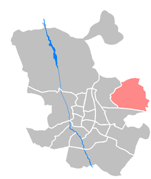
Barajas (municipality)
Barajas is a municipality in the east of Madrid , the capital of Spain . It has 43,423 inhabitants and administratively consists of the districts Alameda de Osuna , Aeropuerto , Casco Histórico de Barajas , Timón (Barajas) and Corralejos . The district of Barajas was incorporated into the administration of Madrid by decree of November 18, 1949, until the restructuring, Barajas was part of the Distrito de Hortaleza.
Origin of name
The origin of the current name Barajas is controversial; although the founding of Barajas is attributed to Roman origins, the name clearly comes from the Arabic term "bar-Axa", which in Arabic means "daughter Axa" (Bar Axa, id est filius Ax). In the font Relaciones histórico-geográficas de los pueblos de España , the place is recorded for the first time in 1575 with "Baraxas".
Worth seeing
Barajas is home to one of the few relics of Spanish military architecture from the 15th century.
- The Castillo de la Alameda also known under the name Castillo de Barajas or Castillo de los Zapata is now used as a museum ( Museo del Yacimiento Arqueológico ) after an extensive restoration . Remains of ancient settlements from the Bronze Age (1500 BC) to the Roman Age (first century AD) exist under the building and in the immediate vicinity. Today the museum is part of the museosdemadrid system .
- Parque de El Capricho , a 14 hectare palace and park.
- Madrid's international airport is located in the northeast of the city district and can be reached by metro.
City festivals
- First week of September each year: Virgen de la Soledad
Web links
Individual evidence
- ^ INE ( Memento of January 2, 2011 in the Internet Archive )
- ↑ Los documentos originales de las Relaciones Histórico Geográficas mandadas hacer por Felipe II se encuentran en la Biblioteca de El Escorial, en ocho volúmenes titulados Descripción de los pueblos de España, donde se recogen las respuestas que cumplimentaron de 636 pudenimienteblos Real Carta de 27 de octubre de 1575, refrendadas por el Secretario Juan Vázquez de Salazar el día 7 de agosto de 1578. De estos originales exist una copia en la Biblioteca de la Real Academia de la Historia realizada en el año 1773 con el título de Relaciones topográficas de los pueblos de España ( the original script, in the Biblioteca de la Real Academia de la Historia be viewed ).
- ↑ http://www.espormadrid.es/2010/05/inaugurada-la-restauracion-del-castillo.html
Coordinates: 40 ° 28 ′ N , 3 ° 35 ′ W


