Carabanchel

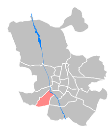
Carabanchel is a municipality in southwest Madrid , Spain . It has 250,000 inhabitants and administratively consists of the districts Comillas (111), Opañel (112), San Isidro (113), Vista Alegre (114), Puerta Bonita (115), Buenavista (116) and Abrantes (117).
history
Archaeological finds confirm a settlement on the terraces of the Manzanares already in prehistoric times since the Paleolithic . However, there is no evidence of this in Roman or Visigoth times. However, there was a Roman post office ( Latin : mansio) called Miacium, which was located above the road that connected Titulcia with Segovia .
In the Spanish Civil War , Carabanchel was the scene of heavy fighting during the Battle of Madrid when nationalist troops tried to conquer the place and suffered heavy losses in street fighting. During the remaining siege of Madrid, the front ran across the streets of Carabanchel until republican Madrid fell on March 28, 1939. The communities Carabanchel Alto and Carabanchel Bajo were incorporated into Madrid in 1948. Up until 1998, Carabanchel was home to one of the most notorious prisons in Spain, where many political prisoners were held during the Franco era.
Major roads
One of the most important streets of Carabanchel is General Ricardos, which runs through almost the entire district. It begins with the Marqués de Vadillo and ends with Eugenia de Montijo.
Other important roads are: Oporto, Antonio López, Antonio Leyva, Vía Lusitana, Abrantes, Camino Viejo de Leganes, Avenida de los Poblados, La Oca, Eugenia de Montijo, Aguacate, Muñóz Grandes, Fátima, Carpetana.
Daughters and sons of the district
- Eduardo Chozas Olmo (* 1960), racing cyclist
- Santiago Segura (born 1965), actor
Web links
- Known residents (Spanish)
- Symbol of the Franco dictatorship - prison is being torn down ( memento from October 25, 2008 in the Internet Archive ) on n-tv.de from October 24, 2008
Coordinates: 40 ° 23 ′ 0.1 ″ N , 3 ° 44 ′ 31.5 ″ W.


