Gero (Gifu)
| Gero-shi 下 呂 市 |
||
|---|---|---|
| Geographical location in Japan | ||
|
|
||
| Region : | Chūbu | |
| Prefecture : | Gifu | |
| Coordinates : | 35 ° 48 ' N , 137 ° 15' E | |
| Basic data | ||
| Surface: | 851.06 km² | |
| Residents : | 31,316 (June 1, 2019) |
|
| Population density : | 37 inhabitants per km² | |
| Community key : | 21220-2 | |
| Symbols | ||
| Flag / coat of arms: | ||
| Tree : | maple | |
| Flower : | Rhododendron indicum | |
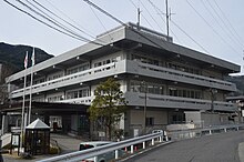
| town hall | ||
| Address : |
Gero City Hall 960 Mori Gero shi Gifu 509-2202 |
|
| Website URL: | http://www.city.gero.lg.jp | |
| Location Geros in Gifu Prefecture | ||
Gero ( Japanese 下 呂 市 , -shi ) is a city in the Japanese prefecture of Gifu .
geography
Gero is northeast of Gifu and south of Takayama .
The Hida River flows through the city.
history
The city of Gero was formed on March 1, 2004 from the union of the communities Gero ( 下 呂 町 , -chō ), Hagiwara ( 萩 原 町 , -chō ), Kanayama ( 金山 町 , -chō ) and Osaka ( 小 坂 町 , -chō ), as well as the village of Maze ( 馬 瀬 村 , -mura ) and the district of Mashita . The district was then dissolved.
traffic
- Street:
- Train:
- JR Takayama Main Line : to Nagoya and Toyama
Attractions
- Gero- Onsen (hot spring)
Town twinning
Neighboring cities and communities
Web links
Commons : Gero - collection of images, videos and audio files


