Barisan Mountains
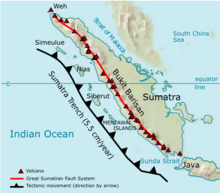
The Barisan Mountains (Indonesian: Bukit Barisan ) is a nearly 1700 km long mountain range that extends parallel to the entire west coast of the island of Sumatra , ( Indonesia ).
The mountain range consists mainly of volcanoes embedded in dense jungle . The highest mountain in the chain is Kerinci at 3800 meters. The Bukit Barisan Selatan National Park is located at the south end of the chain.
The name "Bukit Barisan" means "chain of hills" or "hills that form a line" in the Indonesian and Malay languages .
Individual evidence
- ↑ Reisen in Indonesia, (English) ( Memento from April 19, 2015 in the Internet Archive )
Coordinates: 3 ° 0 ′ S , 102 ° 15 ′ E
