Barra de Carrasco
| Barra de Carrasco | ||
|---|---|---|
|
Coordinates: 34 ° 52 ′ S , 56 ° 2 ′ W Barra de Carrasco on the map of Uruguay
|
||
| Basic data | ||
| Country | Uruguay | |
| Department | Canelones | |
| Residents | 5410 (2011) | |
| Detailed data | ||
| Post Code | 15000 | |
| Location of Barra de Carrasco in the Ciudad de la Costa | ||
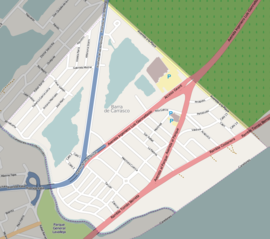
| Plan of Barra de Carrasco | ||
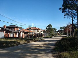
| Street in Barra de Carrasco | ||
Barra de Carrasco is a city in Uruguay .
geography
The coastal city is located on the extreme southwest tip of the Department Canelones in its sector 37 . It borders with its southeast side on the Río de la Plata . Parque Carrasco adjoins the coastline that continues to the northeast , while in the southwest the Arroyo Carrasco forms the border to the neighboring district of Montevideo and the Montevidean district of Carrasco . In the northwest, Barra de Carrasco shares a city boundary with Paso de Carrasco .
Infrastructure
In Barra de Carrasco is the seat of the national Uruguayan tennis association Asociación Uruguaya de Tenis .
Residents
The population of Barra de Carrasco is 5,410 (as of 2011).
| year | Residents |
|---|---|
| 1963 | 524 |
| 1975 | 1,701 |
| 1985 | 2,815 |
| 1996 | 4,306 |
| 2004 | 4,747 |
| 2011 | 5,410 |
Source: Instituto Nacional de Estadística de Uruguay
Web links
- City map of Barra de Carrasco (PDF; 168 kB)
Individual evidence
- ^ Códigos Postales del Interior
- ↑ Official website of the Asociación Uruguaya de Tenis
- ↑ Statistical data from the Instituto Nacional de Estadística de Uruguay , accessed on July 4, 2013
- ↑ Statistical data of the Instituto Nacional de Estadística de Uruguay 1963–1996 (DOC; 87 kB)
- ↑ Statistical data of the Instituto Nacional de Estadística de Uruguay - status 2004 ( MS Excel ; 75 kB), accessed on October 24, 2010


