Basong Tso
|
Basong Tso Basong Co, Basum Tso, Draksum Tso |
||
|---|---|---|

|
||
| Geographical location | Circle Gongbo'gyamda the prefecture-level city Nyingchi in Tibet ( China ) | |
| Drain | → Nyang Qu | |
| Data | ||
| Coordinates | 30 ° 1 ' N , 93 ° 57' E | |
|
|
||
| Altitude above sea level | 3538 m | |
| surface | 26 km² | |
| length | 14 km | |
| width | 2.25 km | |
| Catchment area | 1722 km² | |
|
particularities |
flow regulated |
|
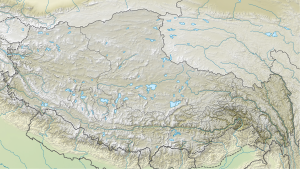
The Basong Tso (also Basong Co , Basum Tso , Draksum Tso ) is a lake in the east of the Tibet Autonomous Region ( PR China ).
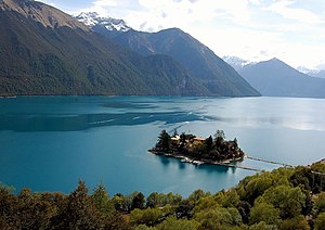
The 14 km long lake is located in Gongbo'gyamda County , 55 km northwest of Nyingchi Township . It lies at an altitude of 3538 m and covers an area of 26 km². The lake is surrounded by mountains up to 6000 m high. The lake extends in an east-west direction and has a maximum width of 2.25 km. Its main tributary flows into the lake at the northeast end. This is fed by the glaciers in the north and northeast. At the western end of the lake, at the drain, there is a dam. The Basong Tso is located on a tributary of the Nyang Qu , a left tributary of the Yarlung Tsangpo . The catchment area of the Basong Tso covers 1722 km².
On the western south bank of Basong Tso there is a small island on which the Tsodzong monastery from the 17th century is located.
Web links
- Photo at tibettravel.org
- Photo at tibettour.org
Individual evidence
- ↑ a b V. H. Phan, RC Lindenbergh, M. Menenti: Geometric Dependency of Tibetan lakes on glacial runoff (PDF (2.2 MB)) Hydrol. Earth Syst. Sci. 17, 4061-4077, 2013.
