Beekhuizen
| Beekhuizen resort | ||
|---|---|---|
|
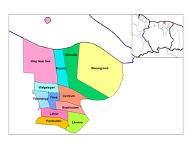
Coordinates: 5 ° 48 ′ N , 55 ° 10 ′ W Ressort Beekhuizen on the map of Suriname
|
||
| Basic data | ||
| Country | Suriname | |
| Department | Paramaribo | |
| Residents | 17,185 (2012) | |
| Detailed data | ||
| surface | 1900 km 2 | |
| Population density | 9 people / km 2 | |
| Waters | Suriname | |
| Time zone | UTC −3 | |
| Map with the resorts of the Paramaribo district | ||
Beekhuizen is a former plantation and one of twelve resorts in the Paramaribo district in Suriname .
According to the 2012 census , Beekhuizen has 17,185 inhabitants.
history
Beekhuizen was established as early as the 17th century, originally as a sugar cane plantation with an area of around 2000 acres (approx. 860 ha ) on the Suriname River - and the Domineekreek .
In 1843 the Moravian Brethren (EBG) acquired the plantation. The EBG had been active in Suriname since 1735. She set up a farm with cattle breeding here to supply the mission budget in Paramaribo . In addition, in 1851, twelve years before slavery was abolished in the Dutch colony of Suriname, a small school was set up to train slave children for the plantations supervised by the EBG.
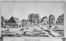
The illustration of the Beekhuizen plantation presented here is a lithograph by Leopold Kraatz in Berlin , based on a drawing by the missionary and teacher Heinrich Peper (1842–1918) who worked for the EBG in Suriname from 1874 to 1883.
At the end of the 19th and beginning of the 20th century, EBG sold large parts of the plantation area and a. to the colonial administration.
The construction of the Lawabahn began in 1903, and by 1905 at the latest, Beekhuizen was also connected to the rail network - see also the photo of the EBG children's home with school and church founded in 1910.
With these and other infrastructure measures, the former plantation was increasingly transformed into a commercial and residential area in the south of Paramaribo.


