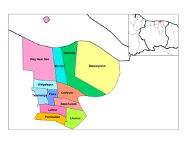
Paramaribo (district)
| Paramaribo District | |
|---|---|
| Location of Paramaribo District in Suriname | |
| Data | |
| Capital | Paramaribo |
| population | 240,924 ( 2012 Census ) |
| surface | 182 km² |
| Population density | 1323.8 inhabitants / km² |
| structure | 12 departments |
| Rivers | Suriname (river) |
| Paramaribo resorts | |
Paramaribo is one of ten districts in Suriname . As a district, it borders the mouth of the Suriname (river) and the Atlantic Ocean in the north . Paramaribo is by far the largest agglomeration of the Republic of Suriname and the capital of the country.
With an area of 182 km², it is the smallest of the districts in Suriname, has around 241,000 inhabitants and is by far the most populous district.
In the parliament ( De Nationale Assemblée ) the district Paramaribo is represented with 17 members.
history
Paramaribo was first permanently settled by the British in the middle of the 17th century with the construction of Fort Willoughby, later renamed Fort Zeelandia . In 1667 the fort was conquered by the Dutchman Abraham Crijnssen . With the Peace of Breda , the region finally passed to the Netherlands.
Administrative division
The Paramaribo district is in turn divided into twelve departments (districts):
- Beekhuizen
- Blauwgrond
- Center
- flora
- Latour
- Livorno
- Mouth
- Pontbuiten
- Rainville
- Tammenga
- Way to Zee
- Welglich
Web links
- Decentralization in Suriname , including financing plans for projects in the districts (Dutch)
Coordinates: 5 ° 49 ′ N , 55 ° 10 ′ W


