Brokopondo (district)
| Brokopondo district | |
|---|---|
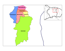
| Location of Brokopondo District in Suriname | |
| Data | |
| Capital | Brokopondo |
| population | 15,909 ( 2012 Census ) |
| surface | 7,364 km² |
| Population density | 2.2 inhabitants / km² |
| structure | 6 departments |
| Rivers | u. a. Suriname |
| Brokopondo departments | |
Brokopondo is a district in Suriname . It borders in the north on the district of Para and on the district of Sipaliwini .
The establishment of the Brokopondo district goes back to the state ordinance No. 104 of December 31, 1958 and originally covered an area of 21,440 square kilometers. The number of inhabitants was at the 1972 census: 17,763 with a population density of 0.83.
The district is known for the Blommesteinsee (dam and power station near Afobaka ), which produces a large part of the energy consumed in Suriname. There are also several nature reserves with rainforest vegetation in Brokopondo.
The Caribbean village of Cabendadorp is located in Brokopondo .
Gold has been mined again in the district for some time . This means that more and more people are immigrating to this district, not only from Suriname, but above all (mostly illegally) from Brazil.
In the parliament ( De Nationale Assemblée ), the Brokopondo district is represented by three members.
Administrative division
The Brokopondo district is in turn divided into the following six departments (decentralized):
- Brownsweg
- Brokopondo
- Klaaskreek
- Kwakoegron
- Marschallkreek
- Sarakreek
literature
- CFA Bruijning, J. Voorhoeve (Red.): Encyclopedie van Suriname. Elsevier , Amsterdam a. Brussels 1977, ISBN 90-10-01842-3 , pp. 101-103.
Web links
- Decentralization in Suriname , including financing plans for projects in the districts (Dutch)
Coordinates: 4 ° 46 ′ N , 55 ° 8 ′ W


