Coronie
| Coronie District | |
|---|---|
| Location of Coronie District in Suriname | |
| Data | |
| Capital | Totness |
| population | 3,391 ( 2012 Census ) |
| surface | 3,902 km² |
| Population density | 0.9 inhabitants / km² |
| structure | 3 departments |
| Rivers | Nickerie |
| Moy cotton plantation in the Coronie district. Ink drawing from the 1860s | |
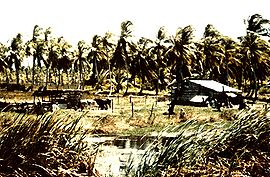
| Coconut palms in Coronie | |
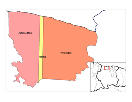
| Coronie departments | |
Coronie is a district in Suriname and is located on the coast of the Atlantic . The Nickerie district borders in the west, the Saramacca district in the east and the Sipaliwini district in the south borders on Coronie.
The entire district lies in the coastal plain and extends only a few meters above sea level. The soils consist almost exclusively of sediments from the so-called younger coastal plain.
History and economy
The Coronie district, formerly known as Opper-Nickerie , was established on October 10, 1851. The history of agriculture began in the time of the English Protectorate (1799–1802) when under Governor Jurriaan François de Friderici large areas were made available for the establishment of plantations. The Scot A. Cameron was the first planter to start the Burnside cotton plantation here in 1808. A flourishing plantation economy with cotton and sugar cane developed . The high point of the cotton culture was the period between 1825 and 1830. Especially after 1860 there was a sharp decline in this culture to the point of complete abandonment.
After 1870 the cultivation of corn , coconut palms and citrus fruits developed . The district owes its current importance to the coconut palms, which led to an important production of coconut oil . Pig farming has developed in this district in connection with the pressed remains of coconut fruits, which are suitable for fattening pigs.
After 1950 the importance of coconut culture declined significantly. Today rice is grown in places . Honey extraction and fishing in the swamp waters are of local importance .
Population and administrative division
At the 1972 census, the population was 3,251; the area at that time was only 1,622 km², so that the population density was 2 inhabitants / km². In 1971 the ethnic composition was as follows: 2,841 Creoles , 325 Javanese , 27 Hindustans , 24 Chinese , 15 Europeans, 4 Maroons , 2 Indigenous and 13 others. Little has changed since then in the district's Creole character.
In 1922 the population was 2,700, in 1950 4,000 and in 1964 3,800. Most of the population emigrated to Paramaribo or the area around the capital.
The population is concentrated along the so-called east-west connection; about half of the population lives in the two places Totness and Friendship.
The Coronie district is in turn divided into the following three departments (decentralized):
- Johanna Maria
- Totness
- Welglich
In the parliament ( De Nationale Assemblée ) the district Coronie is represented by 2 members.
Risk of erosion
The two mud banks Coronie- and Potosibank are located off the coast . These banks are shifting almost permanently and accompany the erosion and accumulation processes on the coast. In the past, the distance between the coast and the so-called east-west connection was between 1 and 4 km. The shift in the coastline is typical for the entire country, but is most pronounced in the Coronie district. Increased erosion processes have been observed since 1957, which threaten the existence of entire polders .
climate
From a climatic point of view, the Coronie district is particularly noticeable due to its relatively low rainfall of only 1600 to 1700 mm per year.
literature
- CFA Bruijning and J. Voorhoeve (main editors): Encyclopedie van Suriname , Elsevier , Amsterdam u. Brussel 1977, ISBN 90-10-01842-3 , pp. 129-131.
- Heinrich E. Helstone, Okke ten Hove, Wim Hoogbergen: Surinaamse Emancipatie 1863 Coronie , Rozenberg Publishers (Bronnen voor de studie van Suriname, deel 28), Amsterdam 2009, ISBN 978-90-3610131-8 .
- Fineke van der Veen, Dick ter Steege, Chandra van Binnendijk: Dromers, Doemdenkers en Doorzetter. Verhalen van mensen en gebouwen in Coronie , KIT Publishers, ISBN 978-94-6022116-3 .
Web links
- Decentralization in Suriname , including financing plans for projects in the districts (Dutch)
Coordinates: 5 ° 46 ′ N , 56 ° 17 ′ W


