Sipaliwini
| Sipaliwini District | |
|---|---|
| Location of Sipaliwini District in Suriname | |
| Data | |
| Capital | Paramaribo |
| population | 37,065 ( Census 2012) |
| surface | 130,567 km² |
| Population density | 0.3 in / km² |
| structure | 6 departments |
| Highest elevation | Julianatop |
| Rivers | u. a. Suriname (river) |
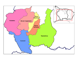
| Sipaliwini's resorts | |
Sipaliwini is a district in the south of Suriname . It has an area of 130,567 km² and is therefore larger than all other districts of Suriname combined.
The name is derived from the language of the Arawaks : sipa means "stone" and wini "water" and "river".
The district does not have its own capital, but is managed directly from Paramaribo . However, he is represented in Parliament ( De Nationale Assemblée ) with four members.
There are border conflicts with Guyana in the southwest of Sipaliwini , as much of the district is claimed by this land.
Administrative division
The Sipaliwini District is in turn divided into the following six departments (decentralized):
- Boven-Coppename
- Boven-Saramacca
- Boven Suriname
- Coeroenie
- Kabalebo
- Tapanahoni
See also
Web links
- Decentralization in Suriname , including financing plans for projects in the districts (Dutch)
Coordinates: 3 ° 47 ′ N , 56 ° 2 ′ W


