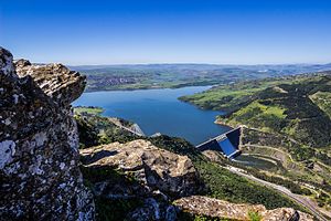
Beni Haroun
| Béni Haroun | |||||||
|---|---|---|---|---|---|---|---|
|
|||||||
|
|
|||||||
| Coordinates | 36 ° 34 ′ 0 ″ N , 6 ° 16 ′ 30 ″ E | ||||||
| Data on the structure | |||||||
| Lock type: | Rolled concrete gravity dam | ||||||
| Construction time: | 1998-2000 | ||||||
| Height of the barrier structure : | 120 m | ||||||
| Height above valley floor: | 118 m (?) | ||||||
| Height above foundation level : | 120 m (?) | ||||||
| Building volume: | 1.9 million m³ | ||||||
| Crown length: | 710 m | ||||||
| Slope slope on the air side : | 1: 0.8 | ||||||
| Power plant output: | 180 MW | ||||||
| Operator: | Agence Nationale des Barrages | ||||||
| Data on the reservoir | |||||||
| Storage space | 963 million m³ | ||||||
| Design flood : | 13 230 m³ / s | ||||||
The Béni Haroun dam is the largest dam in Algeria, both in terms of the height of the structure and the size of the reservoir. It is located in the northeast of the country near Mila , west of Constantine , in the Mila province on the Oued El Kebir river (which is also called Rhumel). The concrete dam made of rolled concrete (RCC) is 120 m high, 710 m long, has a concrete volume of 1.69 million m³ and a total volume of 1.9 million m³. The reservoir has a storage space of 963 million cubic meters.
The connected hydropower plant has a nominal output of 180 MW. In addition to generating electricity, the dam is used to supply drinking water in the provinces of Mila , Jijel , Constantine , Oum el Bouaghi , Batna and Khenchela . It is also important for the irrigation of 30,000 hectares of agricultural land.
The planner of the project was the Belgian office Tractebel Ingénierie, the construction company was the Spanish company Dragados y Construcciones. The inauguration was celebrated in January 2004.
In June 2011, the dam reached 851 million cubic meters, the highest level since the beginning of its gradual damming since 2005. On February 7th 2012 900 million m³ were reached, on February 11th 990 million m³ and on February 12th it was 1 billion m³, approx. 40 million m³ above the theoretical capacity.
See also
- List of the largest dams on earth
- List of the largest reservoirs on earth
- List of the largest hydroelectric plants in the world
- List of power plants in Algeria
- List of dams in the world (Algeria)
swell
- ↑ Algérie: Complexe hydraulique du barrage de Béni Haroun , Algerie-Monde.com, accessed December 7, 2012
- ^ Hafsi Bilel: Le Transport solid et la Qualité des Eaux du Barrage Beni-Haroun et leur Impacts Sur l'environnement . Oum El Bouaghi 2016, Master's thesis of the Université d'Oum El Bouaghi (Université Larbi Ben M'hidi d'Oum El Bouaghi), online at www.bib.univ-oeb.dz (PDF file, French)
- ↑ Barrage de Beni Haroun: un niveau record de 851 millions de m³ , Algérie presse service, June 2011, accessed on December 4, 2012
- ↑ Barrage de Beni Haroun: Appel à la vigilance , Quotidien El Moudjahid, February 7, 2012, accessed December 4, 2012
- ↑ Avec 990 millions de m3, le barrage de Beni Haroun (Mila) dépasse ses capacités théoriques , Algerie Press Service APS, February 11, 2012, accessed December 4, 2012
- ↑ Le barrage de Béni Haroun (Mila) a atteint un pic historique d'un milliard de mètres cubes (Sellal) , Algerie Press Service APS, February 12, 2012, accessed December 4, 2012
- ↑ Barrage de B. Haroun: le Lâcher d'eau, évènement "historique" , Algerie Press Service APS, February 16, 2012, accessed December 4, 2012
Web links
- Beni Haroun Dam , accessed December 3, 2012
- President Bouteflika Inaugurates Beni Haroun Dam (Mila) Message dated January 5, 2004, accessed December 3, 2012
- MD&A database on RCC concrete dams in Algeria - accessed July 25, 2013

