Rhumel
|
Rhumel Rhummel, Rummel |
||
|
Rhumel at Constantine |
||
| Data | ||
| location | northeastern Algeria | |
| River system | Rhumel | |
| source | In Tellatlas above the place Bellaa (Wilaya Sétif) 36 ° 12 '42 " N , 5 ° 51' 18" O |
|
| Source height | approx. 1090 m | |
| muzzle |
Mediterranean Sea , at Jijel Coordinates: 36 ° 52 ′ 20 ″ N , 6 ° 5 ′ 8 ″ E 36 ° 52 ′ 20 ″ N , 6 ° 5 ′ 8 ″ E
|
|
| length | over 200 km | |
| Reservoirs flowed through | Reservoir Oued Athmenia, Reservoir Beni Haroun | |
| Big cities | Constantine | |
| Small towns | Tadjenanet, Chelghoum Laïd, Oued Athmenia, Aïn Smara, El Milia | |
The Rhumel (also Rhummel , Rummel ) is a river in northeastern Algeria , which is best known for its deep gorge in Constantine .
description
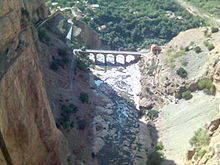
The Rhumel rises about 70 kilometers west of Constantine in about 1090 m altitude in Tellatlas above the village Bellaa in the province of Setif . It initially flows in a south-easterly direction to Tadjenanet on the border with Mila province . From there it meanders in an easterly direction in the wide high valley, which is also used by the national road N 5 to Constantine. It flows over Chelghoum Laïd (ex Châteaudun-du-Rhumel) and through a reservoir in front of Oued Athmania. At Ain Smara the valley narrows, which leads to Constantine, which lies further northeast on a high rock plateau. There, near the ruins of the Roman aqueduct , the river disappears in a gorge around the old town, initially more than 100 m deep, called Oued Rhumel. To the other end in the north of the old town, the gorge is over 175 m deep, whereby the Rhumel leaves it via a waterfall that plunges another 30 m into the depth.
In prehistoric times, the Rhumel river did not cut into the limestone cliffs, but rather looked for a path under the Constantine rock plateau. Over time, the ceiling of this underground river collapsed further and further, so that a ravine with almost vertical walls was created, which offered the old town of Constantine a safe location, separated from the rest of the plateau. Remnants of this ceiling and thus the underground river are still present in the gorge today.
Below Constantine the river is called Oued El Kébir and at some distance is constantly accompanied by the N 27. It flows in a north-westerly direction through the wide hill country and flows into the extensive reservoir Beni Haroun at Grarem . Behind its dam, the Gorges de Beni Haroun and Gorges de Jijel begin, a series of narrow mountain valleys through which the river crosses the Tell Atlas and flows with a significant gradient past El-Milia about 30 km east of Jijel into the Mediterranean Sea .
The Rhumel overcomes a distance of around 200 km calculated in road kilometers. Its actual length is considerably greater due to its numerous turns. Its water is used to a large extent for agriculture, so that it only carries significant amounts of water after abundant rainfall.
Individual evidence
- ↑ The information in this article is largely based on Google Earth and Google maps
- ^ Geography on Constantine d'hier & d'aujourd'hui, Serge Gilard's private website

