Beppu Bay
| Beppu Bay Kantan Bay |
||
|---|---|---|
|
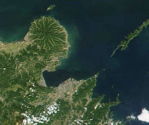
Satellite image of Beppu Bay |
||
| Waters | Seto Inland Sea | |
| Land mass | Kyushu | |
| Geographical location | 33 ° 20 ' N , 131 ° 38' E | |
|
|
||
| width | approx. 20 km | |
| depth | approx. 20 km | |
| surface | 475 km² | |
| Greatest water depth | 70 m | |
| Medium water depth | 36 m | |
| Tributaries | Ōno-gawa , Ōita-gawa | |
The Beppu-Bucht ( Japanese 別 府 湾 , Beppu-wan ), formerly also called Kantan-Bucht ( 菡萏 湾 , Kantan-wan , Eng. "Lotosbucht") after its shape reminiscent of a blooming lotus flower , is a bay of the Seto -Inland Sea in the east of the Japanese island of Kyūshū .
Beppu Bay separates the Kunisaki Peninsula in the north from the Saganoseki Peninsula in the south. To the east of the bay, the Iyo-nada marine region joins the Seto Inland Sea. The 475 km² bay has an average water depth of 36 m and measures 70 m at its deepest point. In the north-west of the bay is Morie Bay ( 守 江湾 , Morie-wan ; 33 ° 24 ′ 24 ″ N , 131 ° 39 ′ 23 ″ E ), also called Kitsuki Bay ( 杵 築 湾 , Kitsuki-wan ). Important tributaries include a. the two rivers of the first order Ōno-gawa and Ōita-gawa , which flow into the south of the bay.
Geologically, it is believed that the bay is a U-shaped rift valley or caldera .
Along the bay communities extend counterclockwise Kitsuki , Hiji , Beppu and Oita of Oita Prefecture .
Uryu-jima
According to historical sources, the island Uryū-jima ( 瓜 生 島 ) with a circumference of 12 km was located in the southern part of the bay about 500 m from Ōita . This is said to have flooded the bay with a 4 m high tsunami during the earthquake of September 4, 1596 , and finally sank. However, topographical studies of the sea floor have so far not provided any indications of their existence.
Web links
Individual evidence
- ↑ a b 別 府 湾 . In: ブ リ タ ニ カ 国際 大 百科 事 典 小 項目 事 典 at kotobank.jp. Retrieved March 15, 2015 (Japanese).
- ↑ a b Kyoichi Tamai: Distribution of Two Characteristic Benthos, Lucinoma annulata (Bivalvia) and Aricidea sp. (Polychaeta) in the Innermost and Deeper Part of Beppu Bay . In: Bull. Nansei Reg. Fish. Res. Lab. No. 12 , 1980, pp. 106 ( PDF ).
- ↑ (5) The Earthquake in Beppu Bay (September 4, 1596, M 7.0). The Headquarters for Earthquake Research Promotion, accessed March 15, 2015 .
- ↑ 沈 [し ず] ん だ 島. City of Ōita, archived from the original on April 2, 2015 ; Retrieved March 15, 2015 (Japanese, original website no longer available).

