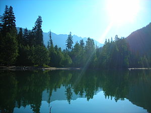
Birkenhead Lake Provincial Park
|
Birkenhead Lake Provincial Park
|
||
|
The beach on Birkenhead Lake |
||
| location | British Columbia (Canada) | |
| surface | 104.39 km² | |
| WDPA ID | 18497 | |
| Geographical location | 50 ° 32 ' N , 122 ° 42' W | |
|
|
||
| Setup date | August 10, 1963 | |
| administration | BC parks | |
The Birkenhead Lake Provincial Park is a 10,439-hectare Provincial Park in the center of the Canadian province of British Columbia . The park is in the Chilcotin Ranges of the Coast Mountains , about 50 kilometers northeast of Pemberton in the Squamish-Lillooet Regional District .
investment
The park is somewhat remote from the large and paved roads on Birkenhead Lake of the same name . Official access to the park and the campground is via a 21 km long unpaved gravel road.
The park is divided into two parts. Most of the park is northwest of Birkenhead Lake, while the smaller part of the park is southeast of the lake. The northeast end of the lake, with the campground, is still in the park. The southwest end of the lake, with a small settlement, no longer belongs to the park.
The park is criss-crossed by various small lakes, streams and rivers. The most important of the streams is Sockeye Creek. There are different mountains in the park area. The highest mountains are:
- Sockeye Horn (2,498 meters, in the northwest of the park)
- Tolkien Peak (2,380 meters, northeast of the park)
- Mount McDonald (2281 meters, in the southeast of the park)
The park is a category II protected area ( national park ).
history
The park was established in 1963 and, like the lake, is named after a sunken ship, the HMS Birkenhead . When it was first established, the park was only 3,642 hectares in size. Over time, the park boundaries were redefined several times and the park grew each time.
The park is mainly located in the traditional hunting and settlement area of the St'at'imc , but also the Squamish . The First Nations still use the area for fishing today.
Flora and fauna
The park is located at the transition between the relatively humid Coast Mountains and the much drier Interior Plateau . Within the British Columbia ecosystem, the park area is assigned to four different zones, the Coastal Western Hemlock Zone (with the subzones dry submaritime and moist submaritime ), the Englemann Spruce - Subalpine fir Zone (with the subzones moist warm and moist warm parkland ), the Interior Douglas-fir Zone (with the subzone wet warm ) and the Alpine Tundra Zone . These biogeoclimatic zones are characterized by a similar climate and the same or similar biological and geological conditions. This results in a very similar population of plants and animals in the respective zones.
A large-scale forestry use did not take place in the park. Therefore there is still a lot of primary forest here . More than 70% of the forest area in the park is more than 140 years old. Due to the four, sometimes very different zones, there is a relatively large number of plants in the park. In addition to widespread species such as Douglas fir , West American hemlock , giant arborvitae and Engelmann spruce, there are also the much rarer species such as western Weymouth pine and mountain hemlock . This biodiversity continues in the undergrowth with Shallon peach berries , red stem moss , umbel winter love and the common Oregon grape.
The detectable animal species correspond to the location of the park. The area also includes the grizzly bear . In addition to various types of red deer, there are also mountain goats in the park . Because of the old trees, the helmeted woodpecker and spotted owl also occur here. Sockeye Creek is also a proven habitat for the protected bull trout , ( Salvelinus confluentus ). Sockeye salmon and rainbow trout can also be found in the lake and the streams and rivers .
activities
The park has 91 parking spaces, some of which can be reserved, for campers and tents and has simple sanitary facilities.
The tourist attraction of the park is on the one hand the Birkenhead Lake and on the other hand the numerous hiking trails and climbing possibilities. The use of mountain bikes is permitted on various paths in the park.
Motorboats are permitted on the lake. It is also an excellent fishing area.
Web links
- Birkenhead Lake Provincial Park . In: BC Geographical Names (English)
- Birkenhead Lake Provincial Park . In: English language website of the park at BC Parks
- Information park on britishcolumbia.com (Engl.)
Individual evidence
- ^ Sockeye Horn in the internet version of the Canadian Mountain Encyclopedia
- ↑ World Database on Protected Areas - Birkenhead Lake Park (English)
- ^ Birkenhead Lake Provincial Park - Management Plan. (PDF; 877.93 kB) British Columbia Ministry of Environment, Lands and Parks , accessed on November 7, 2012 (English).
- ^ Ecosystems of British Columbia. (PDF; 9.85 MB) British Columbia Ministry of Forests, Lands and Natural Resource Operations , February 1991, accessed on February 25, 2013 .
- ↑ Biogeoclimatic Zones of British Columbia. British Columbia Ministry of Forests, Lands and Natural Resource Operations, accessed April 4, 2016 .

