
Blue cap

The Blue Hat was a restaurant in the northwest suburb of Leipzig for about 150 years . Your house sign now adorns the entrance of a residential building.
location
The blue cap stood northwest of the Ranstädter Tor . A dead end east of the Pleißemühlgraben ended at the house. Today the location corresponds to the property at Lortzingstrasse 6.
history
In 1557, at the instigation of Hieronymus Lotter , the Leipzig council created an outbuilding from three houses on garden plots at the location described above , whereby the name Alte Burg appears. This is the name given to the alley that leads there in 1784. When a restaurant was built there around 1700, it must have been named that way. In the 1740s, people talked about the “blue cap” because the landlord supposedly always wore a blue pointed cap . Which of the hosts it was remains a contradiction in terms. A building inspection report from 1745 mentions the "formerly named blue cap", while the Leipzig city lexicon attributes the cap to the innkeeper Heinrich Jäger, who was the innkeeper from the end of the 18th century until 1803. At that time, the Blue Cap is said to have been a notorious gaming club. Johann Gottlob Schulz called the facility in 1784 Reichischer Kaffeegarten .

The Blue Cap 1805, copper engraving by Christian Gottfried Heinrich Geißler

Seen from the Rosentalgasse
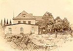
Blue cap and Viennese hall, photograph from 1865

The tenement house Lortzingstr. 6, the former location of the Blauer Mütze


After the Battle of the Nations , over 500 wounded were housed in the premises of the Blauer Mütze. In 1842 a comprehensive renovation took place. A dance hall was created, called the Vienna Hall . In the summer months the theater gave guest performances.
The restaurant was also a popular gathering place. On February 19, 1861, the industrial education association was founded here under the direction of Oskar Mothes . The restaurant was also the headquarters of the Leipzig municipal guard .
When urban development reached the area in the 1870s, the Blue Cap was torn down. The house sign that was recovered was affixed to the entrance of the five-story apartment building on what is now Lortzingstrasse.
literature
- Horst Riedel, Thomas Nabert (ed.): Stadtlexikon Leipzig from A to Z . 1st edition. Pro Leipzig, Leipzig 2005, ISBN 3-936508-03-8 , pp. 52 .
- Ernst Müller: The house names of old Leipzig . (Writings of the Association for the History of Leipzig, Volume 15). Leipzig 1931, reprint Ferdinand Hirt 1990, ISBN 3-7470-0001-0 , p. 40
Web links
Individual evidence
- ↑ City map Leipzig 1832 (digitized version)
- ↑ a b The house names of old Leipzig , p. 40.
- ^ Johann Gottlob Schulz: Description of the City of Leipzig (1784) , Verl. AF Böhm Leipzig, 1784, p. 141 (digitized version) , Reprint Kessinger Pub Co 2009
- ^ Description of the city of Leipzig (1784) , p. 428.
Coordinates: 51 ° 20 '44.3 " N , 12 ° 22' 14.3" E