Boano
| Boano | ||
|---|---|---|
| ISS image by Boano | ||
| Waters | Seramsee | |
| Archipelago | Moluccas | |
| Geographical location | 2 ° 59 ′ S , 127 ° 54 ′ E | |
|
|
||
| surface | 120 km² | |
| Highest elevation | 606 m | |
| Residents | 14,900 124 inhabitants / km² |
|
| main place | Boano (place) | |
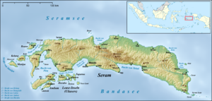
| Boano in the northwest of Seram | ||
Boano ( Indonesian Pulau Boano ) is a 120 km² Indonesian island in the Seram Sea , located about 14 km off the northwest coast of Seram Island .
geography
The Boano waterway separates Boano from Seram. The main town Boano is located on this in the east of the island . There is also another village on the east coast. The small island of Pua is located directly on the northwest coast of Boano .
Boano belongs to the administrative district of West Seram (Seram Bagian Barat), whose de facto main town is Piru on the south side of Seram, on the bay of the same name . The administrative district belongs to the Moluccas Province .
fauna and Flora
Notable among the Boano fauna are the Boano monarch ( Monarcha boanensis ), the green turtle ( Chelonia mydas ) and the hawksbill turtle ( Eretmochelys imbricata ).
Boano is covered in evergreen rainforest . The west consists of inaccessible mountain areas with many overgrown rocks. The eastern part is mostly a flat plain, lined with palm trees and with eucalyptus trees ( Melaleuca kajuputih ). The southern coastal region is surrounded by mangrove forests.
Residents
14,900 people live on Boano. The residents speak Boano , Luhu and Asilulu as their mother tongues . They live from shifting farming , fishing and the production of eucalyptus oil , which is further processed in refineries.
Web links
- "MID17: Pulau Boano (Maluku)" (Indonesian)
Individual evidence
- ↑ Ethnologue 15 report for Indonesia (Maluku) ( Memento from February 26, 2014 in the Internet Archive )


