Bordj Cedria
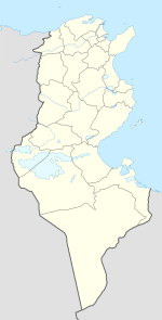
Bordj Cedria ( Arabic برج السدرية Burj as-Sadriyya , DMG Burǧ as-Sadrīya ; French Borj Cédria ) is a village in Tunisia with about 700 inhabitants. It belongs to the Ben Arous governorate and is 25 km east of Tunis , the capital of Tunisia. The village is by the sea, between vineyards and olive groves between karst and reforested ridges, on the northwest slope of the Keddel foothills.
Near the village of Bordj Cedria is the war cemetery of the same name , the Bordj Cedria military cemetery . It is the final resting place for 8562 German soldiers who died in the fighting from November 1942 to May 1943 during the Tunisia campaign in World War II or who died in captivity .
According to various sources, Bordj Cedria is identical to Gummi , the seat of the ancient Gummy Diocese in Proconsulari .
supporting documents
- ↑ http://www.gcatholic.org/dioceses/former/t0905.htm
- ↑ https://www.romanports.org/de/die-hafen/258-gummi.html names two different places called Gummi in Tunisia, one of them Bordj Cedria, the other, Gummi in Africa Byzacena , either today's Henchir-El -Senem or Henchir-Gelama
- ↑ Carte des routes et des cités de l'est de l'Africa à la fin de l'Antiquité, 2010, p. 154. mentions Bordj Cedria as gumis and Mahdia as gum
literature
- Jehan Desanges, Noël Duval, Claude Lepelley et al .: Carte des routes et des cités de l'est de l'Africa à la fin de l'Antiquité: nouvelle édition de la carte des voies romaines de l'Afrique du Nord conçue en 1949, d'après les tracés de Pierre Salama , éd. Brepols, Turnhout, 2010 ( Bibliothèque de l'Antiquité tardive , 17) ISSN 1637-9918
Coordinates: 36 ° 42 ' N , 10 ° 23' E
