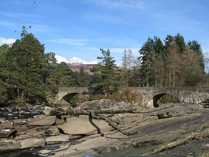
Bridge of Dochart
Coordinates: 56 ° 27 ′ 46 ″ N , 4 ° 19 ′ 12 ″ W.
| Bridge of Dochart | ||
|---|---|---|
| Bridge of Dochart | ||
| use | Road bridge | |
| Convicted | A827 | |
| Subjugated | Dochart | |
| place | Killin | |
| construction | Arch bridge | |
| Number of openings | 4th | |
| completion | 1760 | |
| location | ||
|
|
||
The Bridge of Dochart is a road bridge in the Scottish town of Killin in the Stirling Council Area . In 1971 the building was included in the Scottish list of monuments as an individual monument, initially in category B. The upgrade to the highest monument category A took place in 2006. The bridge should not be confused with the nearby Dochart Viaduct .
history
The Bridge of Dochart was built in 1760. After a flood had caused damage to the bridge, especially the main arch, a partial new construction was necessary in 1831. In the early 19th century, the Falls of Dochart, along with the bridge, Inchbuie Island and today's Folklore Center, formed a well-known motif for artists.
description
The quarry stone viaduct is located on the southern edge of Killin. It spans the Dochart near the Falls of Dochart with four lined segment arches . In addition, there are three passages , which is why seven arches are rarely given. The arches do not have the same width. The Bridge of Dochart leads the A827 ( Ballinluig –Killin) over the Dochart.
Individual evidence
- ↑ a b c Listed Building - Entry . In: Historic Scotland .
- ↑ Entry on Bridge of Dochart in Canmore, the database of Historic Environment Scotland (English)
Web links
- Entry on Bridge of Dochart in Canmore, Historic Environment Scotland database

