Bruce Bay
| Bruce Bay | ||
|---|---|---|
|
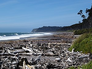
Bruce Bay with Makawhio Point in the background |
||
| Waters | Tasman Sea | |
| Land mass | South Island (New Zealand) | |
| Geographical location | 43 ° 36 '7 " S , 169 ° 33' 58" E | |
|
|
||
| width | approx. 10 km | |
| Tributaries | Mahitahi River , Makaawhio River | |
The Bruce Bay is a bay on the West Coast of the South Island of New Zealand .
geography
The bay is located around 42 km northeast of Haast and a good 40 km southwest of Fox Glacier . It has a length of around 10 km and extends in a north-easterly direction from Heretaniwha Point to Makawhio Point , two prominent rocky elevations on the coast that protrude into the sea.
history
The bay was named after the steamer " Bruce " that anchored in the bay in 1865. The ship served an expedition commissioned by the provincial government at the time, under the leadership of Captain Frederick D. Gibson, explored the Bruce Bay and the Hokarita River . The steamer also picked up 2,700 ounces of gold that gold miners had collected in the area.
literature
- Helga Neubauer: Bruce Bay . In: The New Zealand Book . 1st edition. NZ Visitor Publications , Nelson 2003, ISBN 1-877339-00-8 , pp. 960 .
Individual evidence
- ↑ Topo250 maps . Land Information New Zealand , accessed October 9, 2017 .
- ^ Report of Captain Gibson's Examination of Hokarita River and Bruce Bay. . In: The Colonist . Issue 795 . Nelson June 9, 1865, p. 3 (English, online [accessed December 5, 2015]).

