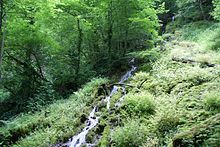
Well climbing cave
| Well climbing cave
|
||
|---|---|---|
|
Entrance of the Brunnensteighöhle |
||
| Location: | Germany | |
|
Geographic location: |
48 ° 35 '19.5 " N , 9 ° 46' 19.2" E | |
|
|
||
| Cadastral number: | 7424/02 | |
| Overall length: | approx. 876 m | |
The Brunnensteighöhle is a water-bearing cave on the edge of the Swabian Alb , located on the northern Albtrauf near the village of Aufhausen .
The source feeds the Autalbach via cascades, which flows into the Fils near Bad Überkingen .
The cave is protected as a geotope under the name Brunnensteighöhle with waterfall .
literature
- Hans Binder , Herbert Jantschke: Cave guide Swabian Alb. Caves - springs - waterfalls . 7th completely revised edition. DRW-Verlag, Leinfelden-Echterdingen 2003, ISBN 3-87181-485-7 , p. 152-153 .
Web links
Individual evidence
- ^ Website Bad Überkingen , accessed on July 3, 2016
- ↑ Homepage of HoeFoDiFi ( Memento of the original from July 3, 2016 in the Internet Archive ) Info: The archive link was inserted automatically and has not yet been checked. Please check the original and archive link according to the instructions and then remove this notice. , accessed July 3, 2016


