
Buen Retiro (Leipzig)

Buen Retiro was the name of an island in a pond in the southwestern suburb of Leipzig , which was used by the people of Leipzig in the 19th century for recreation . The Spanish name means good retreat .
Location and description
Buen Retiro was located in the Schimmel pond, the southernmost of a series of mostly angular ponds, which stretched south-west of old Leipzig in the area of today's music district in a north-south direction. The island was about 300 meters to the west from the raft place . Under today's conditions, this corresponds to a location between Grassi and Ferdinand-Rhode-Strasse at the height of Haydnstrasse.
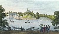
The island around 1840

... and by moonlight


The island was irregular in shape with an average diameter of fifty meters and rose to about five meters above the water level. It was made up of trees and supported some buildings. These were restaurants, one of which also had a bowling alley.
From the north, Buen Retiro could be reached via a wooden footbridge. The waterway could also be chosen with rented rowing boats.
Concerts were organized to entertain the guests. In winter the frozen pond was used as an ice rink.
history
The nuns of the Georgenkloster on the southern edge of Leipzig ran a brick factory in addition to agriculture and a mill ( nun mill ) until around 1540 . They extracted the clay for this in pits in the nearby Pleißenaue, which later became ponds. The southern ponds belonged to a Vorwerk that was owned by the Leipzig merchant Christian Gottlob Frege in the middle of the 18th century . It came to Friedrich Wilhelm Schimmel through other owners in 1823.

Buen Retiro on a plan from 1871

... and in the emerging music district (1884)


On a map from 1784 there were still four manor ponds, over which a tree-lined road cross ran. On a plan from 1796, the stretch between the two southern ponds is missing, and an island is drawn in the now larger pond. Friedrich Wilhelm Schimmel had a “restoration” built on this island and gave it the exotic name of Buen Retiro , not least for advertising reasons . The name was reminiscent of the park of the Buen Retiro Castle in Madrid , which had an artificial lake with an island that visitors could head for with pleasure boats. Schimmel built a boardwalk to the island and introduced boat rentals. Since the excursion offer was very well received, other buildings followed, including a music pavilion and a bowling alley.
An accident in 1842 caused a sensation when the wooden walkway collapsed during fireworks after a concert on the island.
Around 1857 the businessman and real estate investor Friedrich August Adolph Voigt took over the Schimmelsche Gut. In the 1880s, plans began to expand the city in the direction of what would later become the music district. Voigt also submitted a development plan. The ponds were gradually filled in and the entire area was raised by about two meters against the neighboring meadow area for flood protection. At the beginning of the 20th century nothing reminded of Buen Retiro.
In 2015, an ensemble of modern urban villas built near the former island was named Buen Retiro.
literature
- Joana Brauhardt: Buen Retiro on Schimmels Gut . In: Nadja Horsch, Simone Tübbecke (ed.): Citizens' gardens promenades. Leipzig garden culture in the 18th and 19th centuries. Passage-Verlag Leipzig 2018, ISBN 978-3-95415-072-4 , pp. 112-120
- Peter Schwarz: Millennial Leipzig. From the beginning to the end of the 18th century . 1st edition. tape 1 . Pro Leipzig, Leipzig 2014, ISBN 978-3-945027-04-2 , pp. 429 .
- Horst Riedel, Thomas Nabert (ed.): Stadtlexikon Leipzig from A to Z . 1st edition. Pro Leipzig, Leipzig 2005, ISBN 3-936508-03-8 , pp. 526 .
Web links
Individual evidence
- ↑ Joana Brauhardt: Buen Retiro on Schimmels Gut . Pp. 114 and 115
- ↑ Joana Brauhardt: Buen Retiro on Schimmels Gut , p. 118
- ↑ Joana Brauhardt: Buen Retiro on Schimmels Gut . P. 119
- ↑ City map of Leipzig around 1902. Retrieved on February 7, 2019 .
- ↑ Buen Retiro, Schwägrichenstrasse 17/21, Leipzig - Musikviertel. Retrieved February 9, 2019 .
Coordinates: 51 ° 19 ′ 47.3 " N , 12 ° 22 ′ 2.9" E