Cote des Havres
The Côte des Havres (coast of the natural harbors) is part of the west coast of the Cotentin peninsula , which extends from the Cape of Carteret (on the Côte des Isles ) to the Cape of Granville .
Presentation of the coast
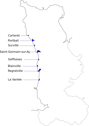
This coast consists of eight natural harbors ("havres"), which have the following characteristics:
- the coast is low, there are beaches made of sand, the chain of dunes is barely pronounced
- they are rivers whose volume flow is large enough for the water to flow through the dunes
- on the coast there is a sea current, the direction of which is constant, which allows the formation of sandy peaks. These sandy headlands partially close the "Havres".
Salt marshes develop within the "Havres" .
The "Côte des Havres" contains:
- Havre of Carteret
- Havre of Portbail ,
- Havre of Surville ,
- Havre of Saint-Germain-sur-Ay ,
- Havre of Geffosses ,
- Havre of Blainville-sur-Mer ,
- Havre of Regnéville-sur-Mer ,
- Havre of la Vanlée ( Bricqueville-sur-Mer ).
The chain of dunes is formed by the sand carried by the sea and the wind. The sand was created by the erosion of the rocky coast, the splintering of the mussel shells , and the sediments carried by the rivers.
This sand has a high lime content.
Behind the coast, vegetables (culture maraîchère) are grown on a large scale.
See also
Individual evidence
- ^ Côte des havres website Wikimanche .
