Cabot Trail
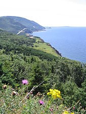
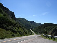
The Cabot Trail is a highway on Cape Breton Island in the Canadian province of Nova Scotia . It forms a panoramic road between the towns of Cheticamp and Ingonish in the northern Cape Breton Highlands National Park , which is considered one of the most beautiful in North America.
The trail is a ring road about 300 km in length. It runs along the west coast of Cape Breton Island, crosses the Cape Breton Highlands at the northern tip , turns south along the east coast and crosses back to the west coast at the level of Bras d'Or Lake through the valley of the Margaree River . The northern part of the trail runs through the Cape Breton Highlands National Park .
The trail is named after John Cabot , who was the first European to explore the island in 1497. Construction of the original trail was completed in 1932. The highway has been expanded several times since then.
literature
- Susan Biagi, Keith Vaughan: Touring the Cabot Trail . Formac, 2005, ISBN 0-88780-658-9 .
- David Lawley: A Nature and Hiking Guide to Cape Breton's Cabot Trail . Nimbus Publishing Ltd, 1995, ISBN 1-55109-105-4 .
Web links
- The Cabot Trail (English)
- NovaScotia.com - Cabot Trail accessed on 11 September 2012 (English)
Coordinates: 46 ° 29 ′ N , 60 ° 45 ′ W

