Caigual
| Caigual | ||
|---|---|---|
|
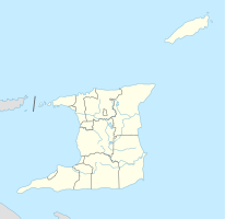
Coordinates: 10 ° 33 ′ N , 61 ° 4 ′ W Caigual on the map of Trinidad and Tobago
|
||
| Basic data | ||
| Country | Trinidad and Tobago | |
| region | Sangre Grande | |
| City foundation | 1894 | |
| Residents | 630 (2011) | |
| Detailed data | ||
| Time zone | UTC −4 | |
Caigual is a place in Trinidad and Tobago . It is located in the Sangre Grande region in the east of the country.
location
Caigual is located in the densely forested southern part of Sangre Grandes, the former Manzanilla Ward . It lies on the eastern edge of the Caroni Plain, which runs through half the island of Trinidad from west to east . The regional capital Sangre Grande is about 8 km northwest, the east coast of the island about 5 km east. South of the village is the Nariva Swamp , the largest wetland in the country. Politically, Caigual belongs to the Cumuto / Manzanilla constituency.
history
From a European perspective, the present urban area was settled at the end of the 19th century, when the British Crown allocated land to several settlers, including a plot of around 20 hectares for a certain Elizabeth Roberts, a free black woman from Arouca , her son In 1894 part of the area was cleared and gradually a cocoa plantation and some fields were established for self-sufficiency. With the arrival of other settlers, some of them from the Roberts family, the area gradually took on the character of a settlement. In 1910, the traveling trader Achoon of Chinese origin founded the town's first shop. In 1916 the villagers built a school on their own initiative, which was recognized by the island's Catholic school board as Caigual RC School and equipped with teaching staff; the first year had 40 students. In the 1920s and 1930s, Caigual was the most populous place in the Manzanilla Ward before Sangre Grande; The main source of income was cocoa cultivation. In the 1940s there was a sudden decline. With the arrival of the US Army on the island in 1941, permitted by the British colonial rulers as part of the destroyer-for-bases agreement , work on their army bases was much more attractive than on the cocoa plantations, and the connection of Sangre Grandes to the Trinidadian power grid 1947 made Caigual even less attractive as a place to live. Due to its remote location, the place could not benefit from Trinidad's oil boom. Due to the lack of accessible workplaces and entertainment options, younger residents gradually moved away. In 2008, after almost 100 years, the Caigual RC School closed with only twelve students left. Today the town has only about 600 inhabitants and most of the buildings have fallen into disrepair.
Economy and Transport
Caigual is connected to Eastern Main Road via Caigual Road, which enables a connection to the East-West Corridor in a north-westerly direction via Sangre Grande and in a south-easterly direction as one of only two overland roads opens up the south-east of Trinidad. Caigual Road is in poor condition so that Caigual is not connected to Trinidad's public transport network. The place is also not connected to the Trinidadian landline network.
Personalities
- Rupert Tang Choon (1914–1985, national cricket player)
Individual evidence
- ↑ Michael Anthony: Towns and Villages of Trinidad and Tobago . 2nd Edition. Printmaster, Marabella 2001, ISBN 978-0-00-976806-4 , p. 23 .
- ↑ Trinidad Newsday of November 19, 2015: Caigual: Plenty land, no people. Retrieved March 28, 2017 .
- ↑ a b Trinidad Newsday of September 6, 2008: Parents: Why was Caigual RC closed? Retrieved March 29, 2017 .
