California State Route 127

|
|||||||||||||||||||||||||||||||
|---|---|---|---|---|---|---|---|---|---|---|---|---|---|---|---|---|---|---|---|---|---|---|---|---|---|---|---|---|---|---|---|
| map | |||||||||||||||||||||||||||||||

|
|||||||||||||||||||||||||||||||
| Basic data | |||||||||||||||||||||||||||||||
| Overall length: | 90.89 mi / 146.27 km | ||||||||||||||||||||||||||||||
| Starting point: |
|
||||||||||||||||||||||||||||||
| End point: |
|
||||||||||||||||||||||||||||||
| Counties: |
San Bernardino County Inyo County |
||||||||||||||||||||||||||||||
| Important city: | Baker | ||||||||||||||||||||||||||||||
|
course
|
|||||||||||||||||||||||||||||||
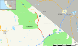
The California State Route 127 (abbreviated CA 127 ) is a state highway in the US state of California . It runs partially through Death Valley National Park .
The highway begins at Interstate 15 in Baker and is on the border of Nevada in the Nevada State Route 373 over.
See also
Web links
- California @ AA Roads route description with photos