Camporrotuno
| Aínsa-Sobrarbe municipality: Camporrotuno | ||
|---|---|---|
 Camporrotuno and below the A-138 motorway
|
||
| coat of arms | Map of Spain | |
 Help on coat of arms |
|
|
| Basic data | ||
| Autonomous Community : |
|
|
| Province : | Huesca | |
| Comarca : | Sobrarbe | |
| Coordinates | 42 ° 21 ′ N , 0 ° 10 ′ E | |
| Height : | 578 msnm | |
| Residents : | 21 (2019) INE | |
| Area code: | 22907000600 | |
Camporrotuno is a Spanish town in the province of Huesca in the autonomous community of Aragon . Camporrotuno belongs to the municipality of Aínsa-Sobrarbe . The place at 578 meters above sea level is about five kilometers south of Aínsa. Camporrotuno only had 21 residents in 2019.
Attractions
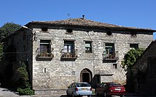
- Houses from the 16th century
Web links
Commons : Camporrotuno - collection of images, videos and audio files


