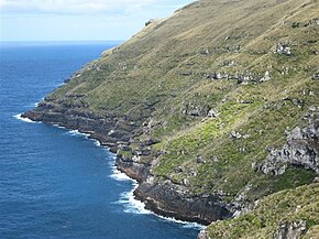
Cape Lovitt
| Cape Lovitt | ||
 View of Cape Lovitt |
||
| Geographical location | ||
|
|
||
| Coordinates | 50 ° 48 ′ S , 165 ° 52 ′ E | |
| location | westernmost point of Auckland Island | |
| Waters | South Pacific Ocean | |
| length | 600 m | |
| width | 375 m | |
| height | 160 m | |
 Auckland Islands with Cape Lovitt as the westernmost point |
||
Cape Lovitt is a cape on Auckland Island , one of the islands of the Offshore Islands of New Zealand .
geography
Cape Lovitt is located on the west coast of the main Auckland Islands . The cape represents the westernmost point of Auckland Island and the entire archipelago. At the same time, the cape, including the offshore 12 nautical mile zone , forms the westernmost territorial border of New Zealand.
The cliffs of the cape are extremely steep and rise to a height of around 160 m . Inland the mountains rise first with the Finger Rocks to 411 m and a little further east with the Fleming Plateau to 552 m .
Individual evidence
- ↑ a b Auckland Islands . (JPG 5.7 MB) Land Information New Zealand , accessed on June 28, 2018 (English).
