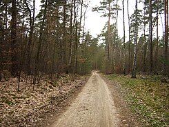
Caputher Heuweg
| Caputher Heuweg | |
|---|---|
| Street in Potsdam | |
| Caputher Heuweg in the Ravensberg mountains as the city limits | |
| Basic data | |
| place | Potsdam |
| District | Waldstadt II |
| Technical specifications | |
| Street length | 6.5 km |
The Caputher Heuweg is a street in the independent city of Potsdam , the capital of the State of Brandenburg, or a forest path in Potsdam-Mittelmark .
course
The Caputher Heuweg originally begins as a forest path branching off to the southeast from the L 78, Heinrich-Mann-Allee, just before the Rehbrücke train station. The road is part of an old connecting path between Caputh and the meadows of the Springbruch. Today, some small streets in the Waldstadt II residential area in Potsdam are also called this. In an almost westerly direction, it runs south past the Kleiner Ravensberg and north of the Teufelssees , crosses the Berlin outer ring and Bundesstraße 2 to merge into Bergholzer Straße in Caputh. The Caputher Heuweg is about 6.5 kilometers long.
history
The Caputher Heuweg, then running almost in a west-east direction, now forms the border between Potsdam and Potsdam-Mittelmark . The Caputher Heuweg originally connected the village of Caputh with the Nuthewiesen near Drewitz . The former village of Drewitz is now part of Potsdam. The Caputher farmers used to have to cover this 10 km long path through the forest in order to reach the meadow areas in the Nuthe lowlands that were necessary for their cattle breeding. The few meadows in the forest and lake-rich area around Caputh were not sufficient for livestock farming.
photos
literature
- Klaus Arlt: The street names of the city of Potsdam, history and meaning ; 2nd edition Potsdam 2010; Association for Culture and History of Potsdam p. 38
Web links
Coordinates: 52 ° 21 '18.6 " N , 13 ° 4' 4.9" E


