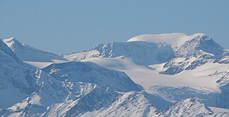
Cariboo Mountains
| Cariboo Mountains | |
|---|---|
|
Outline of the Cariboo Mountains in British Columbia |
|
|
Mount Sir Wilfred Laurier |
|
| Highest peak | Mount Sir Wilfried Laurier ( 3516 m ) |
| location | British Columbia (Canada) |
| part of | Columbia Mountains |
| Coordinates | 52 ° 30 ′ N , 121 ° 0 ′ W |
| surface | 7,700 km² |
The Cariboo Mountains are the northernmost part of the Columbia Mountains , stretching over 245 km in north-south direction and up to 90 km in east-west direction west of the Rocky Mountains in the Canadian province of British Columbia .
geography
The Cariboo Mountains are bounded to the northeast by the Rocky Mountain Trench , through which the Fraser River flows; to the west they go over the hill country known as Quesnel Highlands into the Cariboo Highland or into the Nechako Plateau around Prince George . The 7700 km² area is separated from the Shuswap Highlands by the valley of the North Thompson River to the east and south .
The highest mountain in the Cariboo Mountains - the peaks of which are mostly named after politicians from the province of British Columbia - is Mount Sir Wilfried Laurier with a height of 3516 m west of Valemount .
Larger settlements can be found in the Cariboo Mountains only on the eastern edge along British Columbia Highway 5, which runs in north-south direction, and in the northern area along British Columbia Highway 16 , which runs in east-west direction , the Yellowhead Highway, which is the northern one here Route of the Trans-Canada Highway is.
Mountain ranges within the mountain range
The Cariboo Mountains are divided into:
Protected areas
Large areas of the Cariboo Mountains are protected as Provincial Parks in British Columbia . These provincial parks include:
- Wells Gray Provincial Park
- Cariboo Mountains Provincial Park
- Bowron Lake Provincial Park
- West Twin Provincial Park
- Ptarmigan Creek Provincial Park
- Erg Mountain Provincial Park
Web links
- Cariboo Mountains . In: BC Geographical Names (English)
- Cariboo Mountains on Peakbagger.com (English)
- Cariboo Mountains in the Canadian Mountain Encyclopedia on bivouac.com (English)

