Carretera Nacional N-III
| Carretera Nacional N-III in Spain | |

|
|
| map | |
| Basic data | |
| Operator: | |
| Start of the street: |
Honrubia ( 39 ° 37 ′ N , 2 ° 17 ′ W ) |
| End of street: |
Buñol ( 39 ° 26 ′ N , 0 ° 47 ′ W ) |
| Overall length: | 129 km (current) / 352 (historical) |
|
current: historical: |
|
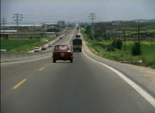
| View of the route of the earlier N-III | |
The Carretera Nacional N-III is a national road in Spain . With a total length of 352 kilometers, it was the shortest of the six national roads starting in a star shape from Madrid and leading to the outer limits of Spain. Today the route only exists on approx. 129 kilometers long sections parallel to the A-3 motorway .
course
The Carretera Nacional N-III led from the capital Madrid via Tarancón , Honrubia , Requena , Siete Aguas , Buñol to Valencia . This route was established around 1940.
In many sections, the national road has already been replaced or expanded to become the A-3 motorway. These are the Madrid - Honrubia, Requena - Siete Aguas and Buñol - Valencia sections. Between Honrubia and Requena and between Siete Aguas and Buñol, the still existing N-III runs parallel to the A-3 motorway .
history
In 1964 work began on increasing the road to the motorway. The route was changed for the first time. The beginning of the street was moved within Madrid to the Avenida del Mediterráneo near the Plaza del Conde de Casal . This 10 kilometer long new building opened on December 9, 1964 and was the first section of the motorway in Spain.
In 1971 this section was extended to at least 25 kilometers and was considered the main thoroughfare for the entry into the capital of Spain. Until the late 1970s, in the cities through which the N-III ran, the two directions of traffic were separated from each other by a yellow stripe and, as an exception, a white stripe. Even in those years, with the exception of certain areas, the top speed was increased from 90 km / h to the top speed of 100 km / h still applicable today. The national road N-III was one of the best developed roads at that time.
In the 1980s, the state of the road began to vary due to increased road traffic in Spain. In the course of the reform of the Spanish constitution in 1982, the road ran through three autonomous communities for the first time . In the middle of this decade, a number of improvements in the course of the road were implemented: Several bypasses were built, dangerous bends were defused.
As a result of Spain joining the European Union in 1986, the largest modernization work was carried out along the N-III in the 1990s. In 1995 the expansion of the N-III to the A-3 motorway between Madrid and Honrubia, which had been ongoing since the late 1980s, was completed. In the 2000s, the expansion to the motorway was completed on all sections. The old route has been preserved between Honrubia and Requena and between Siete Aguas and Buñol.


