
Carrick Roads
Coordinates: 50 ° 9 ′ 12 ″ N , 5 ° 2 ′ 8 ″ W.

The Carrick Roads is an elongated bay in Cornwall . The bay extends as the mouth of the Fal River between Truro and Falmouth .
The Carrick Roads were formed after the last Ice Age when a deeply cut valley was flooded by rising sea levels. The bay forms a large natural harbor and is navigable between Falmouth and Truro. Falmouth Harbor and Carricks Roads are the third largest natural harbor in the world.
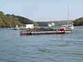
The waterway is from the historic Rollfähre King Harry Ferry crossed. As a car ferry, it connects the villages of Feock and Philleigh .

King Harry Ferry between Trelissick and Roseland
Carrick Roads at Trelissick


Web links
Commons : Carrick Roads - collection of pictures, videos and audio files