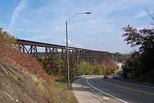
Charlesbourg-Royal
Charlesbourg-Royal was the earliest French settlement in North America . It was in the area of today's city of Quebec ( Cap-Rouge district ) in Canada .
This was located near the confluence of the Rivière du Cap Rouge in the St. Lawrence River , was founded in 1541 by Jacques Cartier and abandoned after two years. The site has been a National Historic Site since 1923 . The exact location of Charlesbourg-Royal had been unknown for a long time until archaeologists came across the first artifacts in 2005.
history
Jacques Cartier , a seafarer from Brittany , first sailed the Saint Lawrence River in 1535 and advanced as far as the Île de Montréal . The area around Stadacona , a village belonging to the Saint Lawrence Iroquois near what is now downtown Québec, seemed to him to be an ideal location for a possible colony. There was no serious attempt to colonize North America in the years that followed. This changed on January 15, 1541, when King François I appointed the courtier Jean-François de La Rocque de Roberval Lieutenant General of New France and commissioned him to build a colony. La Roque, in turn, appointed Cartier to lead the expedition. Five ships with around 350 colonists on board left the port of Saint-Malo on May 23 . La Roque preferred to go on a much more lucrative pirate trip first.
The crossing was difficult and took more than three months. In Stadacona, the colonists (among them a few dozen convicts) were initially warmly welcomed, although the French had kidnapped their chief Donnacona six years earlier . After a short time there was hostility, so Cartier decided to build the colony a little further upstream. The colonists built two forts : at the mouth of the Rivière du Cap Rouge and immediately east of it above a 45 meter high rock face. The settlement was named after Charles, duc d'Orléans , the king's youngest son. Raids by the Iroquois, a severe winter and scurvy troubled the colonists. 35 settlers were killed in a particularly violent attack.
In June 1542, Cartier decided to return to France with the colonists. La Roque had meanwhile finally fulfilled his obligations and set sail from La Rochelle on April 16 with three ships and 200 settlers. On June 8th, he met Cartier in the port of St. John’s ( Newfoundland ), who refused to give orders to return to Charlesbourg-Royal. La Roque finally arrived at Cap Rouge in late July. Once again, the French were exposed to the harsh climate and attacks by the indigenous people. After a short exploration trip further inland, La Roque decided in the spring of 1543 to finally give up the colony and return home with the settlers. He arrived in France in September.
Excavations
The exact location of Charlesbourg-Royal was unknown for centuries. Nonetheless, the area around the estuary was declared a National Historic Site in 1923 . During preparation work for a viewing platform in Parc Cartier-Roberval (above the rock face) remains of the colony came to light in 2005. The government of the province of Québec then commissioned a comprehensive research project under the direction of archaeologist Yves Chrétien. In the following years, more than 4,000 artifacts came to light, which were presented in a special exhibition at the Musée de la civilization in 2012 . At Cap Rouge there is an educational trail with explanations on the history of Charlesbourg-Royal and the excavations.
Web links
- Fort Charlesbourg-Royal National Historic Site of Canada (English)
- Archaeological excavations website (French)
Individual evidence
- ^ A b c Raymond L'Italy: Colonies et empires - lieux de fondation. In: Musée virtuel de la Nouvelle-France. Canada's National Museum of History and Society , accessed October 1, 2014 (French).
- ↑ Le projet. (No longer available online.) In: Projet Cartier-Roberval. Commission de la capitale nationale du Québec, 2014, archived from the original on October 6, 2014 ; Retrieved October 1, 2014 (French). Info: The archive link was inserted automatically and has not yet been checked. Please check the original and archive link according to the instructions and then remove this notice.
- ↑ Visite au chantier archéologique Cartier-Roberval avant la conclusion des travaux. Québec urbain, 2014, accessed October 1, 2014 (French).
Coordinates: 46 ° 44 ′ 53.3 " N , 71 ° 20 ′ 29.7" W.

