
Chemainus (British Columbia)
| Chemainus | |||
|---|---|---|---|
 Wood carving in Chemainus |
|||
| Location in British Columbia | |||
|
|||
| State : |
|
||
| Province : | British Columbia | ||
| Regional District : | Cowichan Valley | ||
| Coordinates : | 48 ° 56 ′ N , 123 ° 44 ′ W | ||
| Area : | 2.09 km² | ||
| Residents : | 3021 (as of 2016) | ||
| Population density : | 1,445.5 inhabitants / km² | ||
| Time zone : | Pacific Time ( UTC − 8 ) | ||
| Postal code : | V0R 1K1 - V0R 1K6 |
||

Chemainus is a municipality in the Canadian province of British Columbia . It is located in the Cowichan Valley Regional District southwest on Vancouver Island . The community lies on the Strait of Georgia, separated by some offshore islands from the Gulf Islands .
history
Chemainus traditionally lives from forestry. In 1858 the community was founded from a settlement of logging camps and on July 1, 1871 the Chemainus Post Office was opened. In 1880 the railway reached the community on its way from Victoria to Nanaimo and led to further growth. The history of the settlement goes back further, however, as the area was already a settlement and hunting area of the First Nation before the settlement of Europeans .
As a parish, the settlement was first officially listed in the 9th Report of the Geographic Board of Canada of June 30, 1910.
On January 13, 2006, a disused Boeing 737 was sunk as an artificial reef off the coast in the Stewart Channel .
Demographics
The last official census , the 2016 Census , showed a population of 3,021 inhabitants for the settlement, after the 2011 census for the municipality still showed a population of 2,914 inhabitants. Compared to the last census in 2011, the population increased by 3.7% and, contrary to the provincial average, developed more slowly, with a population increase of 5.6%. In the census period 2006 to 2011, the number of inhabitants in the municipality had increased by 3.3%, while the provincial average increased by 7.0%.
At the 2016 census, the average age of the residents was 55.7 years, well above the provincial average of 42.3 years. The median age of the residents was determined to be 61.3 years. The median age of all residents in the province in 2016 was 43.0 years. For the 2011 census, a median age of 57.7 years was determined for the residents of the municipality and 41.9 years for the residents of the province.
traffic
In Chemainus there is a ferry terminal of the BC Ferries . Connections to Penelakut Island (formerly Kuper Island) and Thetis Island are served from this terminal .
Furthermore, Highway 1A runs directly through the community, while the Trans-Canada Highway ( Highway 1 ) runs past the community to the west.
A railway line of the Esquimalt and Nanaimo Railway also runs through the community .
tourism
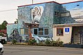
The 39 murals are a tourist attraction of the place. The pictures represent scenes from the past of the place.
Mural painting at the tourist office

Lumberjack at work

Wood transport with ox

Wood transport by Chinese workers

City scene


Web links
Individual evidence
- ↑ a b Chemainus Community Profile. Census 2016. In: Statistics Canada . August 9, 2019, accessed September 4, 2019 .
- ^ Origin Notes and History. Chemainus. GeoBC , accessed September 4, 2019 .
- ^ Chemainus Community Profile. Census 2011. In: Statistics Canada . May 31, 2016, accessed September 4, 2019 .