Chesapeake Bay Crater
The Chesapeake Bay Crater is an approximately 35.5 million year old impact structure on the east coast of the USA , which was only discovered in the early 1990s.
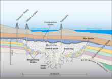
The center of the crater is near the southern tip of the Delmarva Peninsula, which separates the Chesapeake Bay from the Atlantic Ocean . With a diameter of about 85 km and a depth of 1.3 km, it is the largest known impact crater in the United States. The crater is now completely buried under younger layers of sediment and is not visible on the surface of the earth, making it difficult to discover. Impact melts previously discovered in boreholes were mostly interpreted as volcanic rock.
The Chesapeake structure is one of only four impact structures on Earth that are known to have tektites . These tektites, named after their origin as Bediasite (after a place in Texas) or Georgiaite (after the state of Georgia), have been known to science for several decades. Only with the discovery of the Chesapeake crater could the question of their origin be clearly clarified.
The impact led to intense disruption and disruption of the rocks in the vicinity of Chesapeake Bay. Seawater penetrates the groundwater via the fault pathways and today represents one of the greatest problems for the drinking and industrial water supply in the region.
Another, smaller impact crater lies 322 km northeast on the continental shelf off the coast of Atlantic City, New Jersey . It is possible that this crater was caused by the same event in the late Eocene . The crater is part of a geological formation known as Toms Canyon and is approximately 20–22 km wide and approximately 80–100 m below the sea surface.
Web links
- The Chesapeake Bay Crater in the Earth Impact Database
- Information about the Chesapeake impact in English
- Chesapeake Bay Impact Structure Deep Drilling Project Completes Coring
Coordinates: 37 ° 5 ′ 59 ″ N , 75 ° 58 ′ 5 ″ W.

