
Chesterfield Islands
| Chesterfield Islands | ||
|---|---|---|
_(without_Bellona_Reefs_cropped).jpg) |
||
| Waters | Coral sea | |
| Geographical location | 19 ° 21 ′ S , 158 ° 40 ′ E | |
|
||
| Number of islands | 11 | |
| Main island | Île Longue | |
| length | 124 km | |
| width | 68 km | |
| Land area | 85 ha | |
| total area | 4th 765 km² | |
| Residents | uninhabited | |

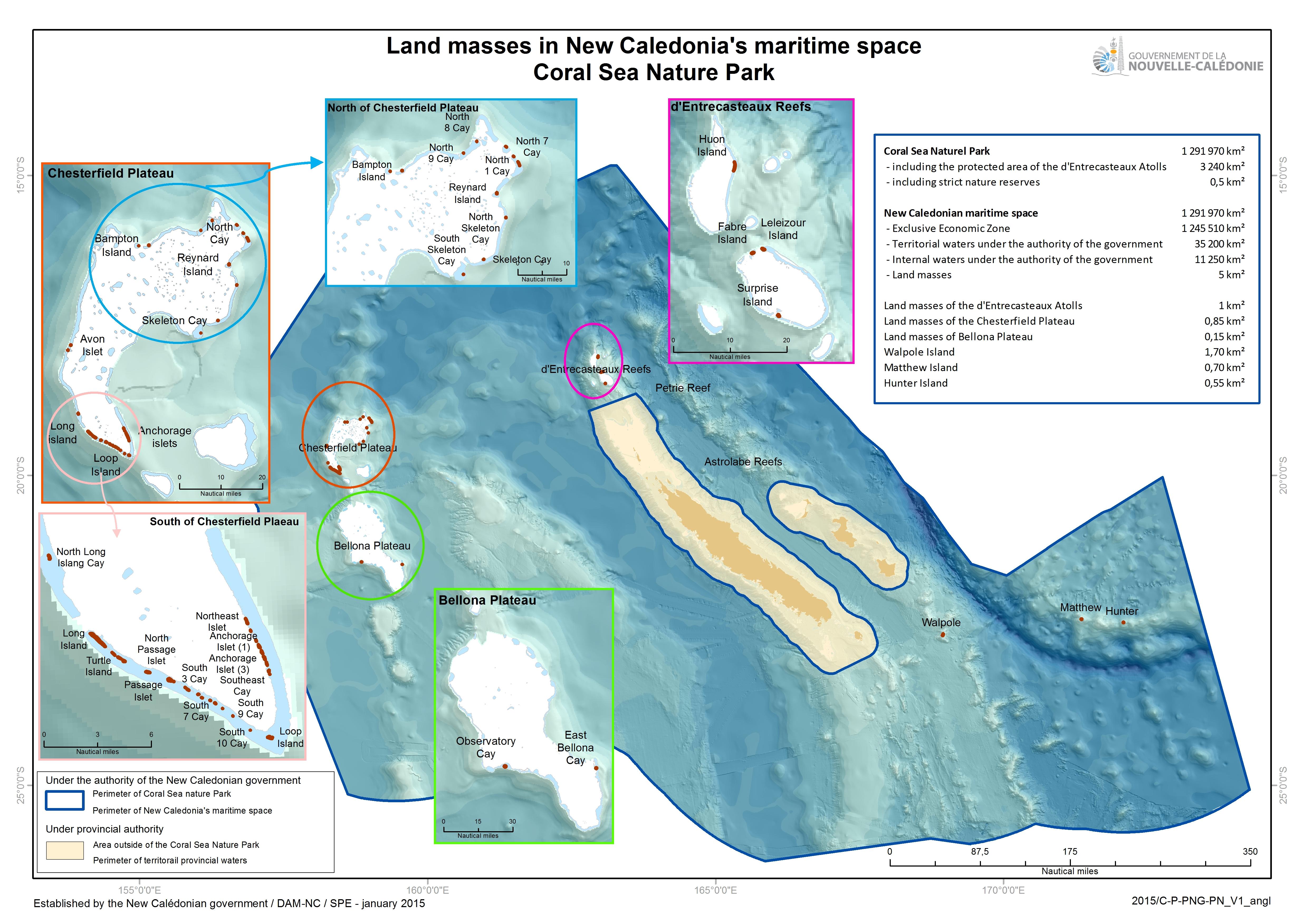
The Chesterfield Islands (also Chesterfield Islands , French Îles Chesterfield ) are an atoll in the coral sea belonging to the South Pacific . They are located west of the reef islands between Australia and New Caledonia , to which they politically belong. They have been under French rule since 1878. The Chesterfield Islands consist for the most part of small islets and reefs that barely rise above sea level. The islands have guano .
The atoll has a total area of 4765 km², making it one of the largest atolls in the world. The published size of only 1104 km² is implausibly low compared to the satellite image, or only refers to the southern part, which is also known as Récifs Chesterfield .
The aggregate land area of the eleven islands is only 0.85 km² or 85 hectares .
The depth of the lagoon is given as 20 to 50 meters.
The smaller southern part of the atoll is also known as Récifs Chesterfield , and the larger northern part is known as Récifs Bampton . The islands include, in counterclockwise order:
- Récifs Bampton
- Caye Skeleton
- Ile Reynard
- Ile Bampton
- Îles Avon ( Avon North and Avon South )
- Récifs Chesterfield
- Îlot de Sable (North Long Island Cay)
- Île Longue
- Îlot du Passage (Bennett Island)
- Îlot loop
- Îlots du Mouillage (Anchorage Islets) (three islands)
The largest island is Île Longue ( English Long Island ), with a length of 1400 to 1800 meters and a maximum width of 100 meters. Avon Sud is the westernmost landmass of the New Caledonia Collectivité .
The extensive Bellona Atoll (Bellona Reefs) begins around 60 kilometers south of the southern tip of the Chesterfield Islands ( Îlot Loop ). In between are Banc de Dumont d'Urville (486 km²), Banc de Boussole (98 km²) and Banc du Vauban (90 km²), all without islands.
The Grand Passage of Chesterfield runs between the Banc du Vauban and the Bellona Atoll .
Occasionally the atolls Chesterfield and Bellona are combined under Chesterfield plateau (French plateau des Chesterfield ).
cards

Map from 1957 showing the southern part of the atoll

Map sketch
_(20346302525).jpg)

Individual evidence
- ↑ Christophe Fonfreyde, F. Jouffroy, E. Bourguat, G. Weiss, B. Guillaumet, Philippe Simoni, Napoléon Colombani, S. Famoetau, Christophe Desgrippes, Guy Hnaja: Chesterfield et Bellona Mission de suivi terrestre, Janvie 2012,
- ↑ Atoll Area, Depth and Rainfall, 2001 ( page no longer available , search in web archives ) Info: The link was automatically marked as defective. Please check the link according to the instructions and then remove this notice. (PDF; 35kB), table from The Geological Society of America . Accessed March 2, 2018
- ↑ F. Cohic: Report on a visit to the Chesterfield Islands, September 1957 (Atoll Research Bulletin No. 63, 1959, p.1 )
- ^ Gouvernement de la Nouvelle Calédonie: Land masses in New Caledonia's maritime space, Coral Sea Nature Park: Land masses of the Chesterfield Plateau
- ^ Nouvelle-Calédonie Tourisme: Parc naturel de la mer de corail
- ↑ Michel PASCAL, Nicolas BARRÉ, Michel DE GARINE-WICHATITSKY, Olivier LORVELEC, Thierry FRÉTEY, Fabrice BRESCIA, Hervé JOURDAN: Les peuplements néo-calédoniens de vertébrés: invasions, disparition, Question 1, p. 116
- ↑ BOURNE, ACF DAVID, IAW McALLAN: The_birds_of_the_Southern_Coral_Sea_including_observation_by_HMS_Herald_in_1858-60 The birds of the Southern Coral Sea including observation by HMS Herald in 1858-60 (2005)
- ^ Gouvernement de la Nouvelle Calédonie, Agence des aires marines protégées: Analysis of Stratégique de l'Espace maritime de la Nouvelle-Calédonie (2014)
- ↑ Excerpt from the nautical chart n ° 6670
- ^ Hervé Jourdan: Les espèces envahissantes dans l'archipel neo-calédonia: Un risque environnemental et économique, 2014