
Bellona (atoll)
| Bellona | ||
|---|---|---|
 |
||
| Waters | Coral sea | |
| Geographical location | 21 ° 25 ′ S , 158 ° 51 ′ E | |
|
||
| Number of islands | 2 | |
| Main island | Caye de l'Observatoire | |
| length | 186 km | |
| width | 77 km | |
| Land area | 15 ha | |
| total area | 9 426 km² | |
| Residents | uninhabited | |
 |
||

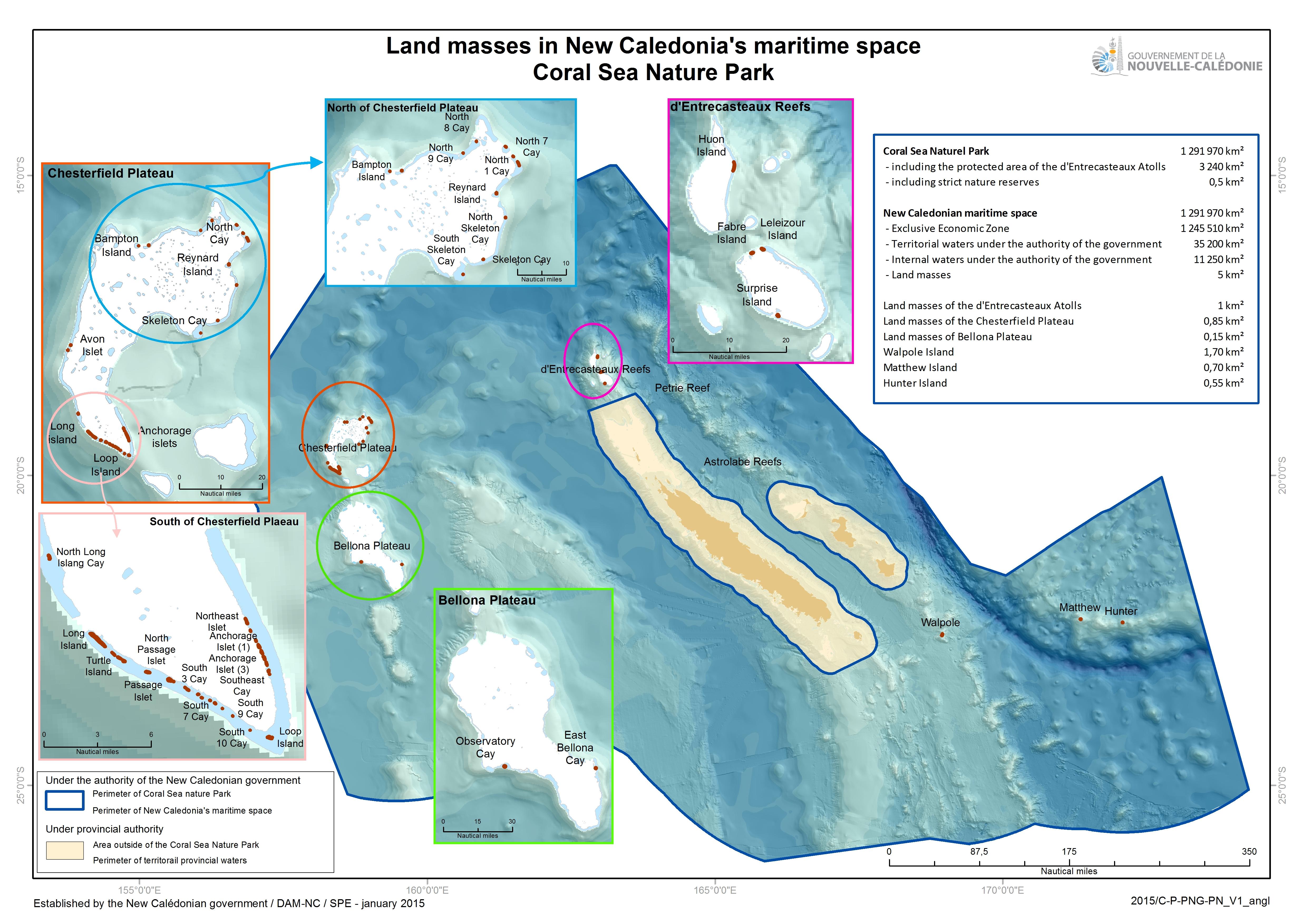
The atoll Bellona ( French Récifs de Bellone , Bellona reefs, also Plateau des Bellona , Bellona Plateau) is a very large atoll in terms of its total area in the coral sea belonging to the South Pacific . It is about 50 kilometers south of the Chesterfield Islands and just under 500 kilometers from New Caledonia , to which it politically belongs. It has been under French rule since 1878.
The atoll has a total area of 9426 km² and is therefore one of the largest atolls worldwide in terms of total area. The large coral ring is only available in parts near the surface and largely sunk.
However, it has only two islands with an aggregate land area of 15 hectares , Caye de l'Observatoire (the main island with an area of around 14 hectares in the area of the Récif Bellona du Milieu / Middle Bellona Reefs) and Caye Est Bellona (one hectare, in the south of the récifs du Sud-Est , the southeastern coral ring ). Caye de l'Observatoire is covered by vegetation according to the satellite image, while the smaller Caye Est Bellona appears without vegetation.
On the nautical chart , depths of 56 (southeast), 60 (middle) and 68 meters (northwest) are indicated in the lagoon .
In the sea manual ( Sailing Directions ) a cay is mentioned at the northeast end of the South Bellona Reefs (Récif Bellona Sud) , which is said to no longer exist since 1988. Nigger Head Rock / Roche Nigger Head is mentioned three kilometers south of the submerged cay , 0.6 m high and made of black coral rock. A report from an ocean mission from 1980 to 1982 states that there is no noteworthy object at the site of the alleged Roche Nigger Head.
Captain Matthew Boyd aboard the Bellona (1782) named the reefs after his ship. He had transported convicts to New South Wales and was on his way to China to pick up a load in Canton for the British East India Company and bring it to Great Britain when he passed the reefs in February and March 1793.

Middle Bellona Reef
Récif Bellona du Milieu
with Caye de l'Observatoire
South Bellona Reef
Récif Bellona Sud


Individual evidence
- ↑ Chesterfield and Bellona
- ↑ Christophe Fonfreyde, F. Jouffroy, E. Bourguat, G. Weiss, B. Guillaumet, Philippe Simoni, Napoléon Colombani, S. Famoetau, Christophe Desgrippes, Guy Hnaja: Chesterfield et Bellona Mission de suivi terrestre, Janvie 2012,
- ^ France, le trésor des régions: Bellona (récifs de la)
- ^ Gouvernement de la Nouvelle Calédonie: Land masses in New Caledonia's maritime space, Coral Sea Nature Park: Land masses of the Chesterfield Plateau
- ↑ Excerpt from the nautical chart n ° 6670
- ^ National Geospatial-Intelligence Agency: East Coast of Australia and New Zealand, Pub. 127, Sailing Directions (enroute), 14th edition: Springfield, Virginia 2017 (PDF; 5.2 MB), 6.10 Bellona Reefs, p. 141
- ↑ Patrick Souquière: MISSION OCÉANOGRAPHIQUE DU PACIFIQUE (5 May 1980–1 October 1982), p. 61