Christoffersen Island
| Christoffersen Island | ||
|---|---|---|
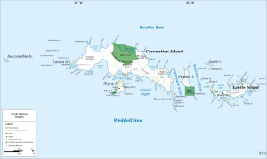
| Map of the South Orkney Islands with Powell Island (center right). Christoffersen Island is the island to the left of the southern tip of Powell Island. | ||
| Waters | Falkland Harbor ( Powell Island ) | |
| Geographical location | 60 ° 44 ′ S , 45 ° 2 ′ W | |
|
|
||
| Residents | uninhabited | |
Christoffersen Island ( Norwegian Christoffersenøya ) is a small island in the archipelago of the Southern Orkney Islands . It is located west of the southern end of Powell Island and is part of the Antarctic Specially Protected Area, ASPA No. 111 .
The name of the island is recorded for the first time on a map drawn up by the Norwegian whaling captain Petter Sørlle on the basis of his surveys of the South Orkney Islands carried out between 1912 and 1913. Presumably namesake is Wilhelm Christoffer Christophersen [sic!] (1832–1913), Norway's Foreign Minister from 1912 to 1913.
Web links
- Christoffersen Island in the Geographic Names Information System of the United States Geological Survey (English)
- Christoffersen Island on geographic.org (English)

